Siliguri Corridor: Why the Chicken’s Neck Matters to India
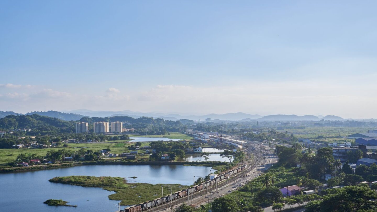
The Siliguri Corridor is a narrow strip of land in North Bengal that joins Northeast India to the rest of the country. At its narrowest point, it is only about 20 to 22 km wide. People call it the “Chicken’s Neck” because of its thin shape on the map. Nepal lies to its west, Bangladesh to its south, and Bhutan to its north, while China’s Chumbi Valley sits a short distance beyond.
Almost every road, railway, fuel pipeline and power line to the eight northeastern states passes through this strip. As a result, the Siliguri Corridor is one of the most closely watched pieces of land in India. It is also a busy travel gateway, since New Jalpaiguri station and Bagdogra airport both sit inside it.
Key takeaways
- The Siliguri Corridor is about 20 to 22 km wide at its narrowest and is the only land link between the Northeast and the rest of India.
- It borders Nepal and Bangladesh directly, with Bhutan to the north and Tibet’s Chumbi Valley close by.
- The 2017 Doklam standoff, from June to August, took place on a plateau overlooking the corridor.
- NH27, the broad-gauge main line through New Jalpaiguri and the Numaligarh product pipeline all cross it.
- In 2026, Indian Railways is planning an underground line and four-line tracks through a strategic stretch of about 40 km.
Siliguri Corridor at a glance
| Detail | Information |
|---|---|
| Location | North Bengal, mainly Darjeeling and Jalpaiguri districts, with edges in Bihar |
| Nickname | Chicken’s Neck |
| Narrowest width | About 20 to 22 km |
| General width | Roughly 17 to 60 km, depending on the definition |
| Length | Often given as about 60 km for the neck; broader definitions run to about 200 km |
| Neighbours | Nepal, Bangladesh, Bhutan; China’s Chumbi Valley nearby |
| Main city | Siliguri |
| Main highway | NH27 (East–West Corridor) |
| Main rail hub | New Jalpaiguri (NJP) |
| Airport | Bagdogra (civil enclave at an Air Force station) |
| Army formation | 33 Corps (Trishakti Corps), headquartered at Sukna |
Where the Siliguri Corridor lies
The Siliguri Corridor runs through the northern tip of West Bengal, between the Himalayan foothills and the plains of Bangladesh. Siliguri city sits near its centre. Furthermore, the Mechi river marks the Nepal border on the western side of the narrowest stretch.
Its exact limits depend on who draws the map. Some defence writers describe a neck about 60 km long and 17 to 22 km wide. In contrast, geography references that count the wider zone give a length of roughly 200 km. Both descriptions agree on one point: the narrowest part is only about 20 to 22 km across.
| Direction | Neighbour | What lies across the border |
|---|---|---|
| West | Nepal | Jhapa district and the Kakarbhitta crossing |
| South and east | Bangladesh | Rangpur division, including Panchagarh and Dinajpur |
| North | Sikkim and Bhutan | Hill roads to Gangtok and Phuentsholing |
| North-east, beyond Sikkim | China (Tibet) | The Chumbi Valley and the Doklam plateau |
The corridor holds the only land route to the Seven Sisters and Sikkim. To see how these states fit together, read our guide to the Seven Sisters of India.
How the Siliguri Corridor came to exist
The corridor is a product of the 1947 Partition. When Bengal was divided, East Bengal went to Pakistan and later became Bangladesh. Consequently, Assam and the hill areas to its east kept only a thin land link with West Bengal.
Sikkim became part of India in 1975, which added another state reached through the same strip. Meanwhile, Nepal and Bhutan both depend on routes through the Siliguri Corridor for much of their trade with India. Therefore, the strip matters to four countries, not just one.
Why the Siliguri Corridor matters strategically
The Siliguri Corridor matters because so much depends on so little ground. Britannica notes that most rail, road, fuel and military supply routes to the Northeast pass through it. A serious disruption here could slow supplies to a region of more than 45 million people.
Several factors raise its importance:
- Single land link: there is no other road or rail route inside India to the eight northeastern states.
- Close to three borders: Nepal and Bangladesh are within a few kilometres at the narrowest stretch.
- Proximity to China: the Chumbi Valley in Tibet pushes south between Sikkim and Bhutan towards the corridor.
- Energy and trade: fuel pipelines and power lines to and from the Northeast run through it.
- Military logistics: the Army’s 33 Corps, based at Sukna near Siliguri, oversees this sector.
In November 2025, media reports said the Army had set up three new garrisons near the corridor. These were at Dhubri in Assam, Kishanganj in Bihar and Chopra in West Bengal. As a result, the security presence around the Chicken’s Neck has grown further.
The Siliguri Corridor and the 2017 Doklam standoff
Doklam is a plateau near the tri-junction of India, Bhutan and China. On 16 June 2017, Indian troops moved to stop Chinese road construction on the plateau, which Bhutan claims as its territory. The standoff lasted until 28 August 2017, when India’s Ministry of External Affairs announced disengagement.
Doklam matters because it overlooks the approaches to the Siliguri Corridor. Bhutan and India saw the planned road as extending towards the Jampheri ridge, which would give a view over the plains below. Consequently, the episode put the Chicken’s Neck back into national headlines.
| Event | Date | Relevance to the corridor |
|---|---|---|
| Partition of Bengal | 1947 | Created the narrow land link |
| Sikkim joins India | 1975 | Added a state reached through the corridor |
| Doklam standoff begins | 16 June 2017 | Chinese road work near the tri-junction |
| Doklam disengagement | 28 August 2017 | Troops pulled back under verification |
| New Army garrisons reported | November 2025 | Security presence expanded nearby |
| Underground rail plan announced | February 2026 | Secure rail capacity through the neck |
If you plan to visit the India–China border in Sikkim, our Nathula Pass guide explains the permit rules. Nathu La also looks down on the Chumbi Valley from the Sikkim side.
Roads, railways and pipelines through the Siliguri Corridor
The Siliguri Corridor carries a dense bundle of transport and energy links. However, they all squeeze through the same small space.
| Link | Route through the corridor | Why it matters |
|---|---|---|
| NH27 | Purnia–Kishanganj–Siliguri–Jalpaiguri–Alipurduar, towards Assam | Main road link on the East–West Corridor |
| NH10 | Siliguri–Sevoke–Rangpo–Gangtok | Main road to Sikkim |
| Broad-gauge main line | Katihar–Kishanganj–New Jalpaiguri–New Cooch Behar–Assam | Trunk rail link to Guwahati |
| Siliguri–Bagdogra–Islampur line | A converted metre-gauge route | Second rail path through the neck |
| Sivok–Rangpo line | Under construction to Sikkim | First rail link to Sikkim |
| Bangladesh–India Friendship Pipeline | Siliguri to Parbatipur, about 131.5 km | Diesel from Numaligarh Refinery to Bangladesh |
Highways
NH27 is part of the East–West Corridor from Porbandar in Gujarat to Silchar in Assam. It crosses the Siliguri Corridor via Kishanganj, Siliguri and Jalpaiguri. Additionally, NH10 leaves Siliguri for Sevoke and follows the Teesta valley to Gangtok, with NH717A as an alternate route.
Railways
New Jalpaiguri (NJP) is the main junction for trains to Assam. The NJP–Guwahati Vande Bharat Express covers 407 km in about five and a half hours, and it runs six days a week. Furthermore, the Sivok–Rangpo line, about 45 km long and mostly in tunnels, will bring trains to Sikkim’s border. Reports put it at about 90% complete in early 2026, with a revised target of 2027.
Pipelines and power
The Bangladesh–India Friendship Pipeline opened on 18 March 2023. It carries diesel from a Numaligarh Refinery terminal at Siliguri to Parbatipur in Bangladesh. Similarly, high-voltage power lines from the Northeast and Bhutan run through the same strip.
New projects to strengthen the Siliguri Corridor
India is adding capacity inside the Siliguri Corridor and building routes that ease the pressure on it. The table below summarises the main projects and their reported status in 2026.
| Project | What it does | Reported status in 2026 |
|---|---|---|
| Underground rail line | Twin tunnels on a strategic stretch near Tin Mile Hat and Rangapani | Planning and survey stage |
| Four-line tracks | Adds tracks on the same strategic stretch | Feasibility under study |
| Sivok–Rangpo railway | Rail link to Sikkim | About 90% complete; target 2027 |
| Bagdogra new terminal | Larger terminal, about ₹3,000 crore | Under construction; target around 2027 |
| Kokrajhar–Gelephu rail link | 69 km rail link to Bhutan | Agreed in September 2025 |
| Banarhat–Samtse rail link | 20 km rail link to Bhutan | Agreed in September 2025 |
Underground railway plan
On 2 February 2026, Railway Minister Ashwini Vaishnaw spoke of “special planning” for the 40 km strategic corridor. He said the plan covers underground railway tracks and four-line expansion of the existing tracks. Later reports placed the tunnels between Tin Mile Hat and Rangapani, near Bagdogra. However, no construction timeline has been published, so treat dates in media reports as provisional.
Rail links to Bhutan
India and Bhutan announced their first cross-border rail links on 29 September 2025. The Kokrajhar–Gelephu line is 69 km long, while the Banarhat–Samtse line is 20 km. Together they cost about ₹4,033 crore. Moreover, the Banarhat–Samtse line starts in the Dooars, just east of the Siliguri Corridor.
Alternative routes that bypass the Siliguri Corridor
Planners have long looked for routes that reduce dependence on the Siliguri Corridor. Most of them run through neighbouring countries, so they depend on diplomacy as much as engineering.
Kaladan Multi-Modal Transit Transport Project
The Kaladan project links Kolkata to Mizoram through Myanmar. Cargo goes about 539 km by sea to Sittwe port, then 158 km up the Kaladan river to Paletwa. From there, a road of about 108 km runs to Zorinpui on the Mizoram border. Sittwe port is operational. However, the Paletwa–Zorinpui road is incomplete, and armed conflict in Myanmar’s Rakhine and Chin areas has delayed work. The government has spoken of a 2027 target.
Transit through Bangladesh
Bangladesh sits between Kolkata and Tripura, so transit through it can shorten journeys sharply. The Akhaura–Agartala rail link was inaugurated on 1 November 2023 with a freight run. Additionally, earlier agreements allowed Indian cargo through Chattogram and Mongla ports. Relations between the two countries have shifted since 2024, therefore the use of these routes has varied.
Political debate in 2025
In March 2025, Bangladesh’s interim chief adviser Muhammad Yunus described the Northeast as landlocked during a visit to China. Assam Chief Minister Himanta Biswa Sarma called the remark unacceptable. He also urged stronger rail and road links through and around the Chicken’s Neck. As a result, the debate over alternative routes gained fresh attention.
The Siliguri Corridor as a travel gateway
For travellers, the Siliguri Corridor is mostly a transit zone rather than a sightseeing spot. Nevertheless, almost every trip to Darjeeling, Sikkim, the Dooars, Bhutan or eastern Nepal passes through it.
| Gateway | Where it is | Common onward trips |
|---|---|---|
| Bagdogra airport (IXB) | About 12 km south-west of central Siliguri | Darjeeling, Kalimpong, Gangtok |
| New Jalpaiguri (NJP) | Southern edge of Siliguri | Gangtok, Darjeeling, trains to Guwahati |
| Siliguri Junction | Central Siliguri | Toy train and regional trains |
| Tenzing Norgay bus terminus | Central Siliguri | Buses to Sikkim, Darjeeling and Assam |
| Panitanki | Nepal border | Kakarbhitta and eastern Nepal |
| Jaigaon | Bhutan border, east of the corridor | Phuentsholing and Thimphu |
Bagdogra handled about 3.2 million passengers in 2024–25, according to published airport statistics. From NJP, Gangtok is roughly 115 to 120 km away, a drive of four to five hours. Shared jeeps and private taxis leave from both the station and the airport.
Indian citizens do not need a permit to pass through the Siliguri Corridor. However, Sikkim’s protected areas and some Northeast states have their own rules. Read our Sikkim permit guide before heading to Nathu La or North Sikkim. For Arunachal, Nagaland, Mizoram and Manipur, see our inner line permit guide.
Travel tips for crossing the Siliguri Corridor
- Allow buffer time: traffic on NH10 and around Siliguri can be slow, especially in peak season.
- Watch the monsoon: landslides on the Teesta valley road often close NH10 between June and September.
- Book NJP trains early: trains to Guwahati and Kolkata fill quickly in October and May.
- Carry ID: Indian travellers entering Nepal or Bhutan need a valid passport or voter ID card.
- Check Bhutan fees: Bhutan charges visitors a daily Sustainable Development Fee, so confirm the current rate before you go.
- Respect restricted zones: photographing military installations around Sukna, Bengdubi and Bagdogra is not allowed.
To time a Northeast trip well, see our month-by-month guide on the best time to visit Northeast India.
Frequently asked questions
How wide is the Siliguri Corridor at its narrowest point?
The Siliguri Corridor is about 20 to 22 km wide at its narrowest point. Britannica gives a figure of roughly 22 km. Some defence analysts describe a range of about 17 to 22 km for the tightest stretch. Wider sections of the corridor reach roughly 60 km, depending on how the boundaries are drawn.
Why is it called the Chicken’s Neck?
The strip earned the name Chicken’s Neck because it looks like a thin neck on the map. It joins the “head” of Northeast India to the “body” of the rest of the country. The nickname also reflects its vulnerability, since a narrow neck is easier to block than a broad land connection.
Which countries border the Chicken’s Neck?
Nepal lies to the west of the corridor and Bangladesh to the south and east. Bhutan lies to the north, beyond the Dooars foothills. China does not touch the strip directly. However, Tibet’s Chumbi Valley pushes south between Sikkim and Bhutan and sits close enough to matter in military planning.
What happened at Doklam in 2017?
In June 2017, Indian troops blocked Chinese road building on the Doklam plateau, which Bhutan claims. The standoff began on 16 June and ended on 28 August 2017, when both sides agreed to disengage. Doklam overlooks the approaches to North Bengal, which is why it drew so much attention in India.
Is there any other land route to Northeast India?
No other land route inside Indian territory links the Northeast with the rest of the country. Alternative routes pass through neighbouring countries. These include the Kaladan project through Myanmar and transit arrangements through Bangladesh, such as the Akhaura–Agartala rail link. Their use depends on project progress and bilateral relations.
Do tourists need a permit to travel through Siliguri?
No. Indian citizens can travel through Siliguri, New Jalpaiguri and Bagdogra without any special permit. Permits apply only further on, for example in protected areas of Sikkim or in ILP states like Arunachal Pradesh and Nagaland. Foreign nationals need separate permits for Sikkim and other restricted zones in the region.
Is the underground railway in the Siliguri Corridor under construction?
Not yet, based on public statements. In February 2026, Railway Minister Ashwini Vaishnaw said the government was planning underground tracks and four-line expansion on a strategic stretch of about 40 km. Reports place it near Tin Mile Hat and Rangapani. No firm construction timeline has been announced so far.
Why the Siliguri Corridor will stay central to the Northeast
The Siliguri Corridor remains the Northeast’s only land link to the rest of India, and its narrow neck shapes defence, trade and travel alike. New tunnels, extra tracks and cross-border links aim to reduce the risk. Meanwhile, for most visitors, the corridor simply marks the start of the journey through Bagdogra or NJP.
Explore more state and region explainers in Northeast Guides or visit the Frontier News homepage.
Related guides
More in Northeast Guides →
Northeast Guides
ADRE Exam and ADRE 3.0: Assam Direct Recruitment Pattern, Process
Northeast Guides
Nijut Moina Scheme 2026: Amount, Eligibility and How to Apply
Northeast Guides