Northeast States and Capitals: Complete List with Key Facts
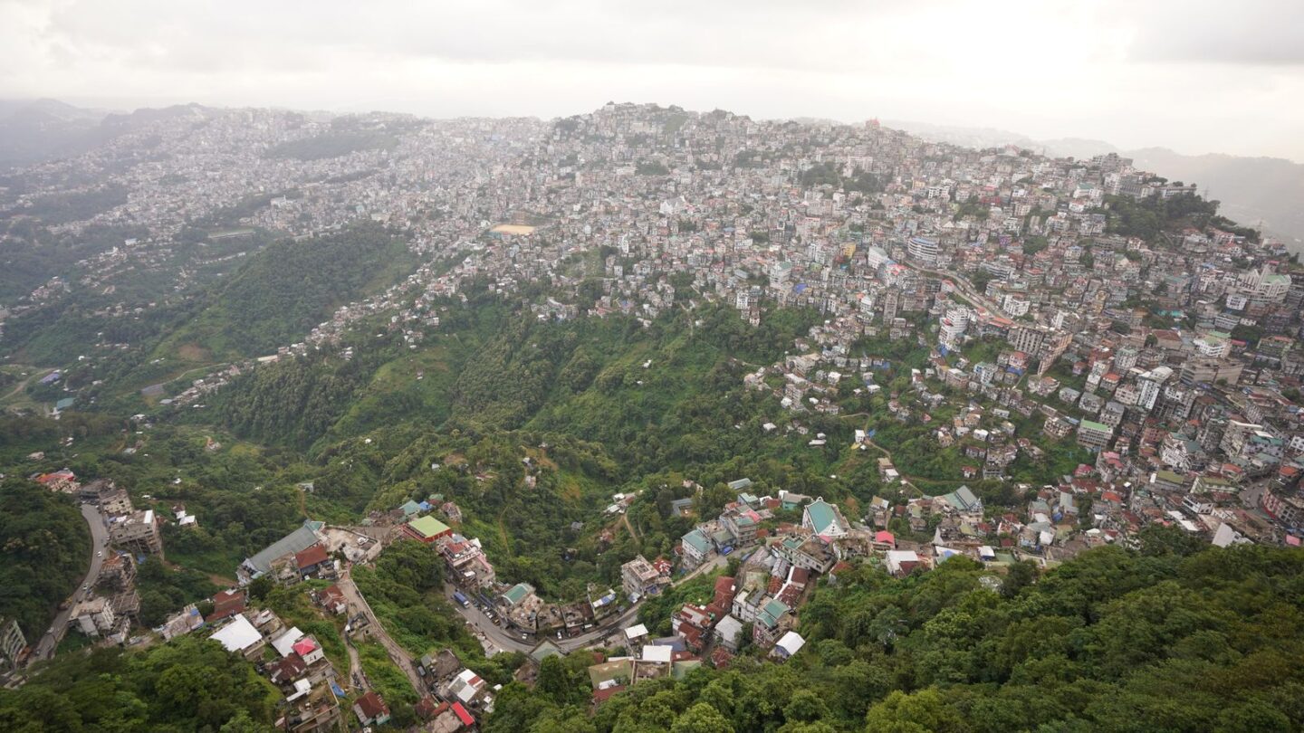
The Northeast states and capitals are eight pairs: Arunachal Pradesh (Itanagar), Assam (Dispur), Manipur (Imphal), Meghalaya (Shillong), Mizoram (Aizawl), Nagaland (Kohima), Tripura (Agartala) and Sikkim (Gangtok). Seven of them form the Seven Sisters, while Sikkim is the eighth member of the region. Guwahati is the main gateway, and only Shillong lies within about 100 km of it by road.
This guide to the northeast states and capitals focuses on the capitals themselves. It covers what each city is known for, how far it sits from Guwahati, and which airport or railhead serves it. For the story of the Seven Sisters name and the region’s borders, read our separate guide to the Seven Sisters of India.
Key takeaways
- There are eight Northeast states and capitals; Sikkim (Gangtok) joined the North Eastern Council in 2002.
- Dispur is a locality inside Greater Guwahati and has been Assam’s capital since 1973.
- Two states have a larger city than the capital: Guwahati in Assam and Dimapur in Nagaland.
- Aizawl joined the national rail network in September 2025, when the Bairabi–Sairang line opened.
- Imphal, Kohima and Gangtok still have no railway station in 2026; new lines are under construction.
Northeast states and capitals at a glance
The table lists all the northeast states and capitals with the year of full statehood and the largest city.
| State | Capital | Full statehood | Largest city |
|---|---|---|---|
| Arunachal Pradesh | Itanagar | 20 February 1987 | Itanagar |
| Assam | Dispur | 1950 (state of the Union) | Guwahati |
| Manipur | Imphal | 21 January 1972 | Imphal |
| Meghalaya | Shillong | 21 January 1972 | Shillong |
| Mizoram | Aizawl | 20 February 1987 | Aizawl |
| Nagaland | Kohima | 1 December 1963 | Dimapur |
| Tripura | Agartala | 21 January 1972 | Agartala |
| Sikkim | Gangtok | 16 May 1975 | Gangtok |
Assam already existed as a province at independence, so its statehood simply dates from the Constitution in 1950. In contrast, the other six sisters were carved out of Assam or upgraded from Union Territories later.
Area, population and languages: Northeast states and capitals compared
The figures below use the 2011 Census, the most recent completed census. Therefore, treat them as a baseline rather than current totals.
| State | Area (sq km) | Population (Census 2011) | Official languages |
|---|---|---|---|
| Arunachal Pradesh | 83,743 | About 13.8 lakh | English |
| Assam | 78,438 | About 3.12 crore | Assamese, Bodo; Bengali in the Barak Valley |
| Manipur | 22,327 | About 28.6 lakh | Manipuri (Meiteilon), English |
| Meghalaya | 22,429 | About 29.7 lakh | English, Khasi and Garo (Khasi and Garo official since April 2026) |
| Mizoram | 21,081 | About 11 lakh | Mizo, English |
| Nagaland | 16,579 | About 19.8 lakh | English |
| Tripura | 10,486 | About 36.7 lakh | Bengali, Kokborok, English |
| Sikkim | 7,096 | About 6.1 lakh | Nepali, Sikkimese (Bhutia), Lepcha, English and others |
Arunachal Pradesh is the largest state by area, while Assam holds well over half the region’s people. Meanwhile, Sikkim is the smallest in both area and population. Sikkim’s language law recognises many more community languages, including Limbu, Newar, Rai, Gurung, Tamang and Sherpa.
Distance from Guwahati to the Northeast states and capitals
Most travellers start in Guwahati, so it is the most useful yardstick for the northeast states and capitals. Road distances vary by route and roadworks, so read them as rough guides.
| Capital | Approx. road distance from Guwahati | Usual road route |
|---|---|---|
| Dispur | Within Greater Guwahati | City roads |
| Shillong | About 100 km | NH-6 via Jorabat and Nongpoh |
| Itanagar | About 320–350 km | Via Tezpur and the Brahmaputra bridges |
| Kohima | Roughly 350–400 km | Via Nagaon and Dimapur |
| Aizawl | Roughly 450–500 km | Via Shillong and Silchar |
| Imphal | Roughly 480–500 km | Via Dimapur and Kohima on NH-2 |
| Gangtok | Roughly 540–560 km | Via Siliguri and NH-10 |
| Agartala | Roughly 550–560 km | Via Shillong, Silchar and Karimganj |
As a result, only Shillong among the northeast states and capitals makes a comfortable day trip from Guwahati. For road options, fares and timings on that route, see our guide on the Guwahati to Shillong distance. For the far capitals, a flight usually saves a full day.
How to reach the Northeast states and capitals by air and rail
Among the northeast states and capitals, every capital except Kohima and Gangtok has an airport close by. However, rail links are still patchy, and three capitals have no station at all in 2026.
| Capital | Nearest airport | Nearest working railhead |
|---|---|---|
| Itanagar | Donyi Polo Airport, Hollongi (about 27 km per the district site) | Naharlagun, about 15 km |
| Dispur | Lokpriya Gopinath Bordoloi International Airport, Guwahati | Guwahati station |
| Imphal | Bir Tikendrajit International Airport, close to the city | Jiribam or Dimapur, both over 200 km away |
| Shillong | Shillong Airport, Umroi (about 30 km); Guwahati for more flights | Guwahati, about 100 km |
| Aizawl | Lengpui Airport, about 32 km | Sairang, on the edge of Aizawl |
| Kohima | Dimapur Airport, about 70 km | Dimapur; new stations at Shokhuvi and Molvom |
| Agartala | Maharaja Bir Bikram Airport, north of the city | Agartala station |
| Gangtok | Bagdogra, about 125 km | New Jalpaiguri, about 120 km |
Shillong’s Umroi airport has limited schedules that change by season. Similarly, Pakyong Airport near Gangtok has seen long gaps in scheduled flights. Therefore, check live airline timetables before you plan around either one.
Rail projects to watch
- Aizawl: the 51.38 km Bairabi–Sairang line opened on 13 September 2025. Trains now link Sairang with Delhi, Kolkata, Guwahati and Silchar.
- Kohima: the Dimapur–Kohima (Dhansiri–Zubza) line has opened to Molvom, but Zubza near Kohima is still under construction.
- Imphal: the 111 km Jiribam–Imphal line is targeted for completion by December 2028, according to state reviews in 2026.
- Gangtok: the Sivok–Rangpo line was about 77% complete in mid-2026, with a December 2027 target. Rangpo is still some distance from Gangtok.
What each of the Northeast states and capitals is known for
Each capital has its own character, climate and main sights. The short profiles below help you choose where to spend time.
Itanagar, Arunachal Pradesh
Itanagar became the capital in the 1970s, commonly dated to 1974. The city takes its name from Ita Fort, the “fort of bricks”, which dates to roughly the 14th–15th century. Additionally, Ganga Lake (Gekar Sinyi) and the Jawaharlal Nehru State Museum draw visitors. Itanagar sits beside its twin town Naharlagun, which has the railway station. The state grew out of the old North-East Frontier Agency, explained in our NEFA full form guide.
Dispur, Assam
Dispur replaced Shillong as Assam’s capital in 1973, after Meghalaya took Shillong. Today it is a locality within Greater Guwahati rather than a separate city. The Assam Secretariat, Janata Bhawan, and the Legislative Assembly stand here. Furthermore, the Guwahati Tea Auction Centre, one of the world’s busiest, operates in the area. Kamakhya Temple and the Brahmaputra riverfront are a short drive away.
Imphal, Manipur
Imphal lies on a wide valley floor ringed by hills. Kangla Fort, the historic seat of Manipur’s kings, stands in the centre. Moreover, Ima Keithel is a large market run entirely by women traders. Loktak Lake, with its floating phumdis, lies less than 50 km south. Parts of Manipur have seen unrest since May 2023, so check official advisories before travel.
Shillong, Meghalaya
Shillong was the capital of undivided Assam until Meghalaya became a state. At roughly 1,500 m, it is cooler than most regional capitals. Popular stops include Police Bazar, Ward’s Lake and Shillong Peak. Consequently, it works well as a base for Sohra, about 55 km away, and Dawki, about 95 km away.
Aizawl, Mizoram
Aizawl spreads along steep ridges, with houses stacked down the slopes. Bara Bazar is the main market, and Solomon’s Temple is a well-known landmark. Visitors often remark on the city’s quiet, orderly traffic. Since September 2025, Sairang station on the city’s edge connects Aizawl to the national rail network.
Kohima, Nagaland
Kohima is best known for the 1944 Battle of Kohima, a turning point in the Second World War in Asia. The Kohima War Cemetery on Garrison Hill marks the site. In addition, Kisama Heritage Village near the city hosts the Hornbill Festival from 1 to 10 December. Dimapur, not Kohima, is the state’s commercial hub and transport gateway.
Agartala, Tripura
Agartala sits close to the Bangladesh border, on flat land unlike most hill capitals. Ujjayanta Palace, built in 1899–1901 by Maharaja Radha Kishore Manikya, is now the state museum. It also housed the Tripura Legislative Assembly until 2011. Neermahal, the lake palace at Melaghar, is a popular day trip.
Gangtok, Sikkim
Gangtok climbs a Himalayan ridge at roughly 1,650 m. MG Marg, a pedestrian-only boulevard, forms the centre of town. Rumtek and Enchey monasteries lie nearby. Meanwhile, Gangtok is the permit base for Tsomgo Lake and Nathula, which need a Protected Area Permit arranged through registered operators.
Permits for visiting the Northeast states and capitals
Permit rules differ sharply across the northeast states and capitals. Four of the eight states require an Inner Line Permit (ILP) for Indian visitors. Our overview of the inner line permit in Northeast India covers each system in detail.
| Capital | Permit for Indian tourists | Notes |
|---|---|---|
| Itanagar | Arunachal eILP | ₹300 up to 3 days, ₹500 up to 14 days |
| Kohima | Nagaland ILP | ₹200, valid 30 days; Dimapur is covered too |
| Imphal | Manipur ILP | ₹100, up to 30 days |
| Aizawl | Mizoram ILP | Temporary pass for a few hundred rupees; confirm on the portal |
| Dispur | None | Open to all Indian citizens |
| Shillong | None | Hotels register guests with the state tourism system |
| Agartala | None | Open to all Indian citizens |
| Gangtok | None for the city | ₹50 tourism fee; PAP for Tsomgo, Nathula and North Sikkim |
Foreign nationals follow different rules. They need a Protected Area Permit for Manipur, Mizoram and Nagaland, and a Restricted Area Permit for Sikkim. Arunachal also requires a PAP for foreigners.
Best time to visit the Northeast states and capitals
October to April is usually the most comfortable season across the northeast states and capitals. However, altitude changes the picture. Shillong, Kohima and Gangtok turn cold in December and January, while Agartala and Dispur stay mild.
| Season | Months | What to expect in the capitals |
|---|---|---|
| Autumn | October to November | Clear skies, festivals, good road conditions |
| Winter | December to February | Cold nights in hill capitals; Hornbill Festival in Kohima |
| Spring | March to April | Pleasant days; pre-monsoon storms may begin |
| Monsoon | May or June to September | Heavy rain and landslides on hill roads |
For month-by-month advice, see our guide to the best time to visit Northeast India.
How the Northeast states and capitals changed over time
The map of the northeast states and capitals looked very different in 1947. At independence, Shillong served as the capital of a much larger Assam. As new states emerged, capitals moved or were built from scratch. Nagaland became a state in 1963 with Kohima as its capital. Later, Meghalaya’s statehood in 1972 left Assam without a capital, so Dispur took over in 1973.
Arunachal Pradesh, earlier NEFA, was administered from Shillong for years before moving to Itanagar. Similarly, Mizoram was a district of Assam, then a Union Territory from 1972, and finally a state in 1987. Sikkim became part of India in 1975, with Gangtok continuing as its capital.
Common mix-ups about the Northeast states and capitals
Quiz questions about the northeast states and capitals often trip over the same points. Keep these in mind.
- Dispur or Guwahati? Dispur is the official capital, but it lies inside Greater Guwahati.
- Kohima or Dimapur? Kohima is the capital; Dimapur has the airport and main railway station.
- Is Shillong still Assam’s capital? No. It has been Meghalaya’s capital since 1972.
- Is Sikkim a Seven Sister? No. It is the eighth Northeast state, often called the “brother”.
- Is Gangtok reached via Guwahati? Usually not. Most travellers use Bagdogra or New Jalpaiguri in West Bengal, beyond the Siliguri Corridor.
Frequently asked questions
What are the eight Northeast states and capitals?
The eight Northeast states and capitals are Arunachal Pradesh (Itanagar), Assam (Dispur), Manipur (Imphal), Meghalaya (Shillong), Mizoram (Aizawl), Nagaland (Kohima), Tripura (Agartala) and Sikkim (Gangtok). The first seven form the Seven Sisters. Sikkim became part of India in 1975 and joined the North Eastern Council in 2002.
Is Guwahati the capital of Assam?
No. Assam’s capital is Dispur, which has served as the capital since 1973. However, Dispur lies within Greater Guwahati, so the two are often confused. Guwahati is the largest city in Assam and in the whole Northeast. It also has the region’s busiest airport and main railway station.
Which Northeast capital is closest to Guwahati?
Apart from Dispur, which lies inside Greater Guwahati, Shillong is the closest of the northeast states and capitals. It sits about 100 km away on NH-6, usually a drive of three to four hours. Itanagar comes next at roughly 320–350 km. Every other capital is more than 350 km away by road.
Which Northeast capitals have no railway station?
Among the northeast states and capitals, Imphal, Kohima and Gangtok have no railway station of their own in 2026. Imphal travellers use Jiribam or Dimapur, while Kohima travellers use Dimapur or the new stations at Shokhuvi and Molvom. Gangtok is served by New Jalpaiguri in West Bengal. Rail lines to all three capitals are under construction.
Which Northeast states and capitals need an Inner Line Permit?
Indian tourists need an Inner Line Permit for four of the northeast states and capitals: Itanagar, Kohima, Imphal and Aizawl. Arunachal Pradesh, Nagaland, Manipur and Mizoram all use the ILP system. Dispur, Shillong, Agartala and Gangtok need no ILP. However, protected areas around Gangtok, such as Tsomgo Lake and Nathula, require separate permits.
Which is the largest capital in Northeast India?
Guwahati, which contains Dispur, is by far the largest urban area in the Northeast. Among stand-alone capitals, Agartala, Imphal, Shillong and Aizawl are the larger cities. Kohima is smaller than Dimapur, Nagaland’s commercial hub. Gangtok and Itanagar are compact hill towns with fewer residents than most regional capitals.
How do I reach Aizawl by train?
Aizawl joined the Indian rail network on 13 September 2025, when the Bairabi–Sairang line opened. Trains now run from Sairang, on the edge of Aizawl, to Delhi, Kolkata, Guwahati and Silchar. The Sairang–Anand Vihar Rajdhani Express is the flagship service. Book early, because demand has been high since the line opened.
Planning a trip across the Northeast states and capitals
The Northeast states and capitals range from Dispur’s government offices to Gangtok’s Himalayan ridges. Distances between the northeast states and capitals are long, rail links are still growing, and four states need permits. Therefore, plan flights for the far capitals, carry your permits and allow buffer days for weather.
Find more state explainers in our Northeast Guides section, or return to the Frontier News homepage.
Related guides
More in Northeast Guides →
Northeast Guides
Districts of Assam: Full List of 35 Districts with Headquarters
Northeast Guides
Siliguri Corridor: Why the Chicken’s Neck Matters to India
Northeast Guides