Sela Pass: Altitude, Sela Lake, Tunnel and Road Conditions in 2026
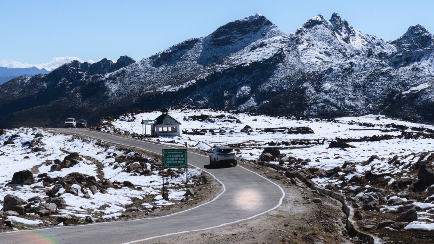
Sela Pass is a high mountain pass at about 4,170 m (13,700 ft) on the road between Dirang and Tawang in western Arunachal Pradesh. It sits on the boundary of West Kameng and Tawang districts and carries NH-13, the main road into Tawang. Since 9 March 2024, the Sela Tunnel has run beneath the pass, so traffic no longer has to cross the summit in winter.
Travellers still drive up to Sela Pass for its frozen lake, snow views and war history. Therefore, most Tawang trips now include a short detour over the old pass road when the weather allows. Indian visitors need an Arunachal tourist eILP, which costs ₹300 for up to 3 days or ₹500 for up to 14 days.
Key takeaways
- Sela Pass stands at about 4,170 m, or roughly 13,700 ft according to the Tawang district administration.
- Sela Lake lies just below the summit on the Tawang side and often freezes in winter.
- The Sela Tunnel, built by the Border Roads Organisation for about ₹825 crore, opened on 9 March 2024.
- Jaswantgarh War Memorial, honouring Rifleman Jaswant Singh Rawat, lies about 20 km beyond the pass.
- Snow can still block the pass road between roughly December and March, so check conditions each morning.
Sela Pass at a glance
| Detail | Information |
|---|---|
| Altitude | About 4,170 m (about 13,700 ft) |
| State | Arunachal Pradesh |
| Districts | Boundary of West Kameng and Tawang |
| Highway | NH-13 (earlier NH-229) |
| Nearest towns | Dirang to the south, Jang and Tawang to the north |
| Main lake | Sela Lake, on the northern side |
| Tunnel below | Sela Tunnel, opened 9 March 2024 |
| War memorial | Jaswantgarh, about 20 km towards Tawang |
| Permit | Arunachal eILP for Indians; PAP for foreigners |
| Snow season | Roughly December to March, sometimes later |
Where Sela Pass is and how high it sits
Sela Pass lies on the only main road into Tawang from the plains of Assam. The road climbs from Dirang in the Kameng valley, crosses the pass and then drops towards Jang. Finally, it climbs again to Tawang town at about 3,000 m.
Sources quote slightly different heights. The Tawang district administration and Incredible India give about 13,700 ft. Meanwhile, most reference sources give 4,170 m. These figures match closely, so “about 4,170 m” is a safe number. However, some travel sites round it up to 4,200 m or even higher.
The pass is one of the highest motorable passes in the Northeast. As a result, it sits well above the tree line, with bare slopes, small lakes and prayer flags. A gateway at the Sela Pass summit welcomes travellers into Tawang district.
Sela Lake: the frozen lake below the pass
Sela Lake lies just north of the summit, at roughly 4,160 m. The road runs along its shore, so you can see it without a trek. Local Buddhists regard the lake as sacred, and it drains into the Nuranang river.
In winter, the lake often freezes completely. Consequently, many visitors plan a trip between December and March to see it white. In contrast, the lake shows deep blue water from April to November, with rhododendrons around it in spring.
Do not walk on the frozen surface of Sela Lake. District advisories warn that ice on high lakes can break without warning.
Several smaller lakes dot the slopes around the pass. However, reaching them needs local guidance and good weather, and the ground is often boggy or icy.
The Sela Tunnel and how it bypasses Sela Pass
The Border Roads Organisation built the Sela Tunnel to keep Tawang connected all year. Prime Minister Narendra Modi laid the foundation stone on 9 February 2019. He dedicated the tunnel to the nation on 9 March 2024, according to PIB.
| Tunnel detail | Figure |
|---|---|
| Tunnel 1 | About 980 m, single tube |
| Tunnel 2 | About 1,555 m, twin tube (one traffic tube, one escape tube) |
| Link road between tunnels | About 1,200 m |
| Altitude | About 13,000 ft |
| Cost | About ₹825 crore |
| Built by | Border Roads Organisation, using the New Austrian Tunnelling Method |
| Distance saved | About 10 km on the Dirang–Tawang road |
The BRO describes Tunnel 2 as the longest bi-lane road tunnel in the world above 13,000 ft. Furthermore, the tunnel avoids the highest, most snow-prone bends below the summit. Estimates of time saved vary, from about an hour to more in winter.
Should you take the tunnel or the pass?
The tunnel is faster and safer in snow. Therefore, drivers use it for most through traffic. However, the tunnel skips Sela Lake and the summit views. Most tourists take the old road over Sela Pass on the way to Tawang in good weather. Then they use the tunnel on the way back, or whenever snow closes the top.
Jaswantgarh and the legend of Sela
The pass is closely linked with the 1962 war between India and China. In November 1962, Chinese forces advanced through the area, then part of the North-East Frontier Agency. Our guide to the NEFA full form explains how that frontier was run.
Rifleman Jaswant Singh Rawat of the 4th Battalion, Garhwal Rifles, fought in the Battle of Nuranang on 17 November 1962. He helped silence a Chinese machine-gun position. According to popular accounts, he then held his post for a long time, often told as 72 hours, before he was killed. He received the Maha Vir Chakra posthumously.
Jaswantgarh War Memorial
The army renamed his post Jaswantgarh, and a war memorial now stands there. It lies about 20 km beyond Sela Pass towards Jang, and roughly 52 km before Tawang. The Indian Army maintains the memorial, and soldiers posted there keep his story alive. Most travellers stop here for tea and a short visit.
The legend of Sela and Nura
Local tradition says two Monpa sisters, Sela and Nura, helped Rawat during the fighting. According to the story, Sela died, and the pass and lake took her name. Similarly, Nuranang Falls near Jang is said to be named after Nura. Historians treat the details as legend rather than documented fact. Nevertheless, the story remains central to how the Sela Pass area remembers 1962.
Sela Pass road distances from Dirang and Tawang
The distances below are approximate. Road works, detours and the choice of tunnel or pass change the figures. Therefore, use them for planning and check live maps before you drive.
| Stretch | Approximate distance | Typical drive time |
|---|---|---|
| Guwahati to Dirang | About 350 km | 9 to 11 hours |
| Dirang to Sela Pass | About 50 to 60 km | 2 to 3 hours |
| Sela Pass to Jaswantgarh | About 20 km | 45 minutes to 1 hour |
| Jaswantgarh to Jang (Nuranang Falls area) | About 20 km | 45 minutes to 1 hour |
| Sela Pass to Tawang | About 70 to 80 km | 2.5 to 3.5 hours |
| Dirang to Tawang (full leg) | About 125 to 135 km | 4 to 6 hours |
The full Guwahati to Tawang drive is about 480 km. Our Guwahati to Tawang road guide breaks it into stages with fares and night halts. Most travellers sleep in Dirang or Bomdila, then cross Sela Pass early the next morning.
Sela Pass road conditions by month
Weather at Sela Pass changes quickly, even in the same day. Mornings are usually clearer, while fog and cloud often build after noon. Consequently, drivers try to cross before about 1 pm.
| Months | Typical conditions | What to expect |
|---|---|---|
| December to February | Heavy snow, frozen lake, icy road | Pass road may close for hours or days; tunnel usually carries traffic |
| March | Snow still common | Late snow is possible; vehicles were halted at the pass by snow in late March 2026 |
| April to May | Snow melting, clearer skies | Good season; lake reappears and rhododendrons bloom |
| June to September | Monsoon rain, fog, landslides | Slow driving, poor views, possible blocks lower down the route |
| October to November | Dry, clear, cold | Best views; freezing nights and early snow possible |
Snow closures and chains
Heavy snow still disrupts the route in some winters. For example, in February 2025 the road between Baisakhi and Tawang lay under snow, and snow chains became mandatory. Furthermore, district officials told travellers to check forecasts and avoid frozen lakes.
The tunnel has reduced long closures on the main road. However, the approaches can still ice over. Therefore, carry chains in winter, drive in daylight and follow army and police instructions at the pass.
Permits you need to cross Sela Pass
Indian citizens from outside Arunachal Pradesh need an Inner Line Permit. The tourist eILP costs ₹300 for up to 3 days or ₹500 for up to 14 days. Staff check it at Bhalukpong on the Assam–Arunachal border, and at other points on the route. Our Arunachal ILP guide explains the online steps and documents.
| Traveller | Permit needed | Notes |
|---|---|---|
| Indian tourist from outside Arunachal | Tourist eILP | ₹300 (3 days) or ₹500 (14 days) |
| Resident of Arunachal Pradesh | None | Carry ID |
| Foreign national | Protected Area Permit | Usually via a registered tour operator |
| Travellers to Bum La or border lakes | Extra local permission | Arranged in Tawang after arrival |
No separate entry fee is widely reported for Sela Pass itself. Nevertheless, keep your eILP and original ID ready, because army and police posts may check them. For a wider view of regional permits, see our inner line permit guide.
Altitude sickness at Sela Pass
Sela Pass is far higher than Dirang, where most travellers spend the night before. As a result, headaches, breathlessness or nausea can start within minutes at the top. The Tawang district administration advises a night halt in Dirang or Bomdila for acclimatisation.
- Keep the stop short, usually 20 to 40 minutes at the summit.
- Walk slowly and avoid running or climbing the slopes.
- Drink water and avoid alcohol on the day you cross.
- Wear layers, gloves and a warm hat, even in summer.
- Descend at once if symptoms get worse, since Jang and Tawang lie lower.
- Consult a doctor before travel if you have heart or lung problems.
Children and older travellers feel the height more. Therefore, keep them warm and watch them closely at the lake.
Best time to visit Sela Pass
The best time depends on what you want to see. For snow and a frozen lake, visit from December to March. However, road closures are more likely then. For clear roads and views, October to November and April to May work best.
The monsoon months bring fog and landslides, so they are the least reliable. For a region-wide seasonal plan, read our best time to visit Northeast India guide. Additionally, our Tawang travel guide covers the monastery, lakes and a full itinerary beyond the pass.
Practical tips for crossing Sela Pass
- Start early from Dirang, ideally by 7 am, to cross before the afternoon fog.
- Hire a local driver in winter; hill drivers know the icy sections.
- Fill fuel in Dirang, since pumps are few before Tawang.
- Carry cash, as mobile networks and card payments can fail near the top.
- Keep snacks and hot drinks, because stalls at the pass may close in bad weather.
- Respect restrictions: do not photograph military installations or convoys.
Small tea stalls near the summit usually sell noodles, tea and snacks in good weather. However, they may shut during storms, so do not rely on them.
Frequently asked questions
What is the altitude of Sela Pass?
Sela Pass stands at about 4,170 m, or roughly 13,700 ft. The Tawang district administration and Incredible India both give about 13,700 ft. Some travel sites round the figure to 4,200 m. The Sela Tunnel below the pass sits lower, at about 13,000 ft, according to PIB, which is why it stays usable in snow.
Is Sela Pass open in winter?
The main road to Tawang stays open in most winter weather, because traffic now uses the Sela Tunnel. However, the old road over Sela Pass can close for hours or days after heavy snow. Snow chains may become mandatory. Check with your driver, hotel or local police each morning before you set out.
Can tourists use the Sela Tunnel?
Yes. The Sela Tunnel was dedicated to the nation on 9 March 2024 and carries normal traffic, including tourist cars and buses. It has two tunnels of about 980 m and 1,555 m, joined by a link road. The tunnel skips Sela Lake, so tourists usually drive over the pass when conditions allow.
How far is Sela Pass from Tawang?
Sela Pass lies roughly 70 to 80 km from Tawang by road, which usually takes about 2.5 to 3.5 hours. The road descends past Jaswantgarh War Memorial and Jang before climbing to Tawang. From Dirang, the pass is about 50 to 60 km away. Drive times vary with weather, army convoys and road works.
Do I need a permit for Sela Pass?
Yes. Indian tourists need an Arunachal Pradesh tourist eILP, which costs ₹300 for up to 3 days or ₹500 for up to 14 days. Foreign nationals need a Protected Area Permit, usually arranged through a registered operator. No separate entry fee is widely reported for the pass itself, but officials may check permits along the road.
Who was Jaswant Singh Rawat?
Jaswant Singh Rawat was a rifleman in the 4th Battalion, Garhwal Rifles. He fought in the Battle of Nuranang on 17 November 1962 and was killed after holding his position. He received the Maha Vir Chakra posthumously. The Jaswantgarh War Memorial, about 20 km beyond Sela Pass, honours him.
Why is it called Sela Pass?
Local tradition links the name to Sela, a Monpa woman who reportedly helped Rifleman Jaswant Singh Rawat in 1962 and died during the fighting. Her sister Nura is said to give her name to Nuranang Falls. Historians regard these details as legend. Nevertheless, the story is widely told at Jaswantgarh and across Tawang district.
Plan your Sela Pass crossing with care
Sela Pass rewards an early start, warm clothes and a flexible plan. Use the tunnel when snow closes the top, and take the old road for Sela Lake when skies are clear. Carry your eILP, stop briefly at Jaswantgarh and let the altitude set your pace.
Find more route and permit guides in Permits & Routes or visit the Frontier News homepage.
Related guides
More in Permits & Routes →
Permits & Routes
Manipur ILP 2026: How to Apply Online, Fees and Entry Gates
Permits & Routes
Mizoram ILP 2026: Online Application, Fees and Validity
Permits & Routes