Sela Tunnel: Length, Location and Why It Matters in 2026
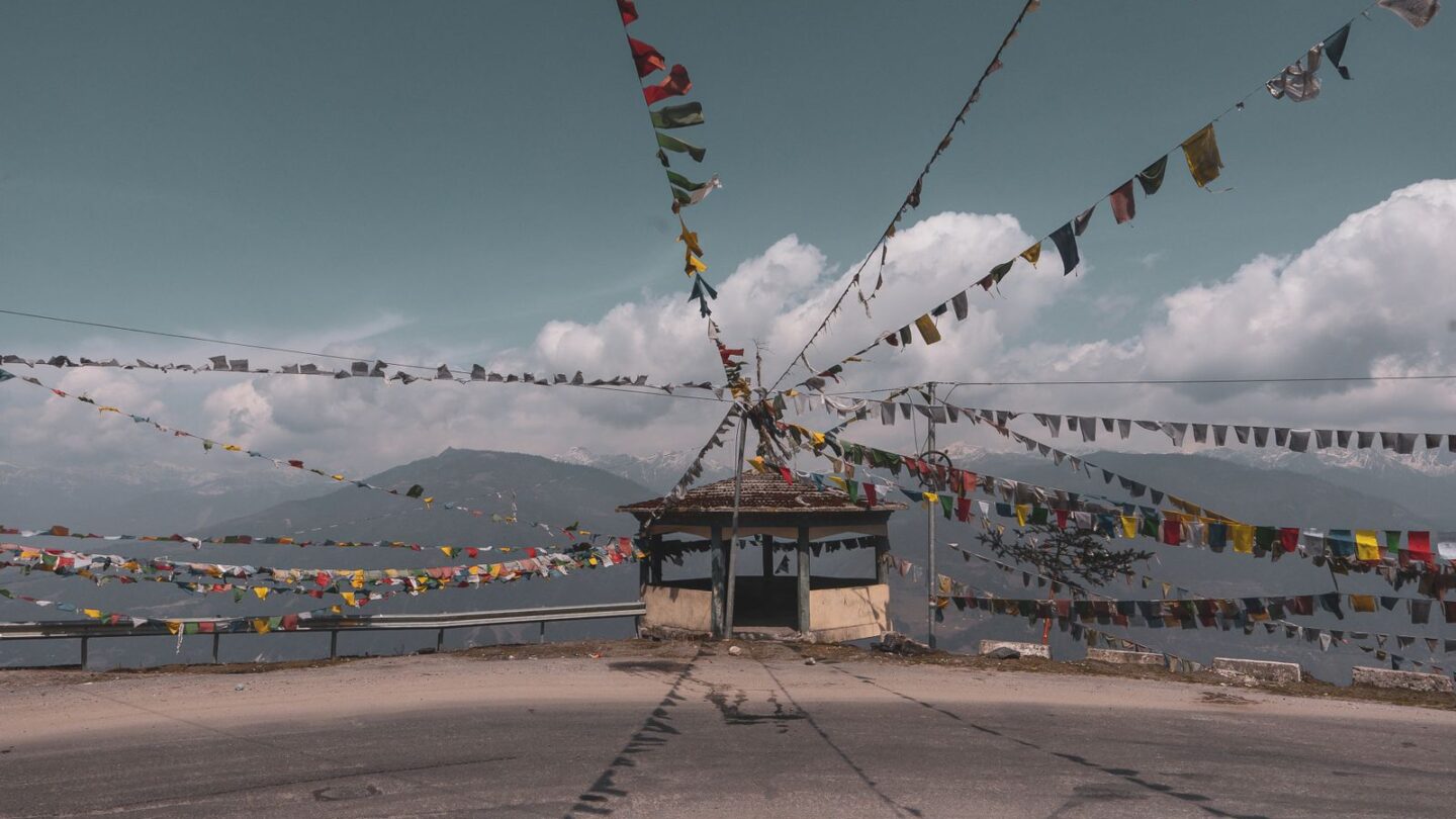
The Sela Tunnel is a pair of road tunnels at about 13,000 ft that carries NH-13 under Sela Pass, on the only main road to Tawang in Arunachal Pradesh. Tunnel 1 is about 980 m long and Tunnel 2 about 1,555 m, and the Border Roads Organisation (BRO) built them for about ₹825 crore. Prime Minister Narendra Modi dedicated the project to the nation on 9 March 2024.
The tunnels give Tawang all-weather road access for the first time. Before 2024, snow on the old pass road could cut the town off for days. Now, most traffic between Dirang and Tawang runs underground for a short stretch, while tourists can still drive over the pass to see Sela Lake.
Key takeaways
- The Sela Tunnel system has two tunnels, of about 980 m and 1,555 m, joined by a link road of roughly 1.2 km.
- Tunnel 2 has a separate escape tube for emergencies, running parallel to the traffic tube.
- The tunnels sit at about 13,000 ft, well below Sela Pass at about 4,170 m (13,700 ft).
- The BRO built it under Project Vartak using the New Austrian Tunnelling Method, for about ₹825 crore.
- It shortens the Dirang–Tawang road by roughly 8 to 10 km and saves about an hour, often more in snow.
Sela Tunnel at a glance
| Detail | Information |
|---|---|
| Location | Below Sela Pass, West Kameng–Tawang boundary, Arunachal Pradesh |
| Road | NH-13, the Balipara–Chariduar–Tawang road |
| Portals | Baisakhi side (south) and Nuranang side (north) |
| Tunnel 1 | About 980 m, single tube |
| Tunnel 2 | About 1,555 m, traffic tube plus escape tube |
| Altitude | About 13,000 ft (BRO gives a portal height of about 3,973 m) |
| Cost | About ₹825 crore |
| Built by | Border Roads Organisation, Project Vartak |
| Foundation stone | 9 February 2019 |
| Opened | 9 March 2024 |
| Toll or entry fee | None widely reported |
Where the Sela Tunnel is located
The Sela Tunnel lies in western Arunachal Pradesh, on the road between Dirang and Tawang. It cuts through the Sela–Chabrela ridge, which forms the boundary between West Kameng and Tawang districts. According to ANI reporting from the site, the alignment links the Baisakhi area on the southern side with the Nuranang side to the north.
In practice, drivers coming from Dirang climb steadily towards the Baisakhi area. The new road then leaves the old pass road and heads for the tunnel portals. Meanwhile, the old road continues up the hairpins to the summit and Sela Lake. Both routes meet again on the Nuranang side, before the descent towards Jaswantgarh and Jang.
The tunnels run several kilometres west of the pass summit. Furthermore, several reports describe the tunnel as sitting roughly 400 m below the pass. That lower height is the main reason it stays open when the summit is buried in snow.
Sela Tunnel length and technical details
Official figures differ slightly by source. The PIB release on the final blast in January 2022 gives Tunnel 1 as 980 m and Tunnel 2 as 1,555 m. However, some inauguration-day reports quote about 1,003 m and 1,595 m. Frontier News uses the PIB and BRO figures, which also appear in our other Tawang guides.
| Component | Approximate figure | Notes |
|---|---|---|
| Tunnel 1 | 980 m | Single tube carrying two-way traffic |
| Tunnel 2 | 1,555 m | Bi-lane traffic tube |
| Escape tube | Parallel to Tunnel 2 | Linked by cross passages |
| Link road between tunnels | About 1.2 to 1.3 km | Open-air section |
| Approach and link roads | Roughly 8.6 to 9 km in total | Figures vary by report |
| Design traffic | 3,000 cars and 2,000 trucks a day | As reported at inauguration |
| Maximum speed | 80 km/h | Design figure; follow posted limits |
The BRO calls Tunnel 2 the longest bi-lane road tunnel in the world above 13,000 ft. As a result, the project drew national attention far beyond Arunachal Pradesh.
How the BRO built it
The BRO used the New Austrian Tunnelling Method, or NATM. This approach excavates by drill and blast, then uses the surrounding rock itself as part of the support. Crews spray concrete and fix rock bolts soon after each blast. Consequently, the method suits the mixed, fractured rock of the Himalaya.
Work continued through harsh winters, with temperatures well below freezing. The final blast on Tunnel 2 took place on 22 January 2022. Additionally, reports at the opening mentioned about 90 lakh man-hours of work and roughly 650 workers on site each day.
Escape tube, ventilation and safety features
Tunnel 2 is long enough to need a separate emergency route. ANI reported that tunnels longer than about 1,500 m require an escape passage. Therefore, the BRO built a second, parallel tube beside the traffic tube.
- Escape tube: runs alongside Tunnel 2 and connects to it through cross passages. Reports mention several passages at intervals of up to about 500 m.
- Ventilation: jet fans inside the tunnel move fresh air and push out exhaust fumes.
- Lighting: an illumination system built to CIE (International Commission on Illumination) norms eases the change from bright snow to tunnel light.
- Fire safety: firefighting equipment sits along the tunnel for quick response.
- Monitoring: a SCADA control system tracks ventilation, lighting and safety equipment.
Details such as the number of cross passages differ between reports. However, all sources agree the escape tube exists only on Tunnel 2. Tunnel 1, being shorter, is a single tube.
Do not stop, park or take photos inside the Sela Tunnel. Keep headlights on, hold your lane and follow the instructions of BRO and army staff at the portals.
Why the Sela Tunnel matters
The main road to Tawang crosses high, snow-prone country for many hours. Before the tunnel, the summit section of Sela Pass often closed after heavy snowfall. Consequently, Tawang residents, traders and soldiers could be stranded for days in winter.
All-weather access for Tawang
The Sela Tunnel keeps the highest stretch of the route open for most of the year. Buses, trucks, taxis and supply convoys no longer need the summit bends in winter. As a result, fuel, food and medicine reach Tawang more reliably. Tourism also benefits, because winter trips have become far more practical.
Strategic importance
Tawang lies close to the Line of Actual Control with China. The area also has deep historical weight, since Chinese forces advanced through it in 1962, when it formed part of the North-East Frontier Agency. Our explainer on the NEFA full form covers that period.
A reliable road lets the Indian Army move troops, weapons and heavy machinery quickly in any season. Therefore, PIB and defence reporting describe the Sela Tunnel as a strategic asset as well as a civilian road. Similarly, the smaller Nechiphu Tunnel, dedicated in 2023, bypasses a fog-prone stretch lower down the same route.
Sela Tunnel vs the old Sela Pass road
Both routes remain open to traffic when the weather allows. However, they suit different purposes, and many travellers use both on one trip.
| Factor | Sela Tunnel route | Old Sela Pass road |
|---|---|---|
| Highest point | About 13,000 ft | About 13,700 ft at the summit |
| Winter reliability | Usually open | May close for hours or days after snow |
| Driving time | Shorter by roughly an hour | Slower, with steep hairpins |
| Distance | Roughly 8 to 10 km shorter | Longer |
| Sela Lake and summit gate | Not visible | Road runs past the lake |
| Best for | Through traffic, winter travel, return trips | Sightseeing on clear days |
For the summit experience, the lake and the war history of the area, read our full Sela Pass guide. It covers Sela Lake, Jaswantgarh and month-by-month road conditions.
Can you still visit Sela Lake?
Yes. The tunnel does not replace the old road; it bypasses it. Drivers can still take the pass road to the summit gate and Sela Lake, then rejoin the highway on the Nuranang side. In heavy snow, though, officials may close the pass road while the tunnel stays open. Consequently, ask your driver or hotel about the pass each morning.
What travellers see at the Sela Tunnel
The drive through is short. Tunnel 1 takes about a minute at normal speed, and Tunnel 2 only slightly longer. In between, the open link road gives wide views of bare slopes and, in winter, deep snow.
The portals carry BRO signage and the tunnel name. Army and BRO staff often man the approaches, and photography rules can apply near military areas. Moreover, stopping at the portals can block traffic on a narrow mountain road. Therefore, take any photos only where your driver says it is safe and allowed.
No separate toll or entry fee for the tunnel is widely reported. However, you still need the correct permit to be in Arunachal Pradesh at all, and checkpoints may ask for it.
Driving the Sela Tunnel route from Dirang to Tawang
The Sela Tunnel sits on the second day of the classic Guwahati–Tawang drive. The full road trip is about 480 km, and most travellers break it at Dirang or Bomdila. Our Guwahati to Tawang road guide gives every stage with fares and night halts.
| Stretch | Approximate distance | Typical drive time |
|---|---|---|
| Guwahati to Dirang | About 350 km | 9 to 11 hours |
| Dirang to Sela Tunnel (Baisakhi side) | About 45 to 55 km | 1.5 to 2.5 hours |
| Through both tunnels and the link road | A few kilometres | About 5 to 10 minutes |
| Sela Tunnel to Jaswantgarh | Roughly 15 to 20 km | 30 to 45 minutes |
| Dirang to Tawang via the tunnel | About 115 to 125 km | 4 to 5 hours |
| Dirang to Tawang via the pass | About 125 to 135 km | 4.5 to 6 hours |
These distances are estimates. Road works, convoys and weather change them. Furthermore, map apps sometimes still show the old alignment, so trust local drivers over apps near Sela.
Time saved: what to expect
Official and news sources put the time saving at about one hour between Tezpur and Tawang. In winter, the real gain can be far larger, because the pass road may be blocked entirely. In contrast, on a clear summer day, much of the saving disappears if you detour over the pass for Sela Lake.
Permits and rules for the Sela Tunnel route
Indian citizens from outside Arunachal Pradesh need an Inner Line Permit to use this road. The tourist eILP costs ₹300 for up to 3 days or ₹500 for up to 14 days. Staff check it at Bhalukpong and at other posts. Our Arunachal ILP guide explains the online process and documents.
| Traveller | Permit needed | Notes |
|---|---|---|
| Indian tourist from outside Arunachal | Tourist eILP | ₹300 for 3 days or ₹500 for 14 days |
| Arunachal resident | None | Carry photo ID |
| Foreign national | Protected Area Permit | Usually through a registered operator |
| Anyone using the tunnel | No separate tunnel pass | Carry permit and ID at checkpoints |
Foreign nationals cannot use a domestic eILP. Instead, they need a Protected Area Permit, normally arranged through an approved tour operator.
Winter travel through the Sela Tunnel
The tunnel reduces winter risk, but it does not remove it. The approach roads on both sides still climb above 3,500 m. For example, heavy snowfall in February 2025 made roads around Tawang impassable for a time, and snow chains became mandatory between Baisakhi and Tawang. Similarly, vehicles were halted at the snow-covered pass in late March 2026.
- Check conditions with your hotel, driver or local police before leaving Dirang.
- Carry snow chains from December to March, even if you plan to use the tunnel.
- Drive in daylight, since black ice forms on the approaches after dark.
- Wear warm layers, because the portals sit near 4,000 m and winds are strong.
- Watch for altitude symptoms; headaches and breathlessness can start near the tunnel.
- Keep fuel topped up in Dirang, as pumps are few before Tawang.
For seasonal planning across the region, see our guide to the best time to visit Northeast India. October to November and April to May usually bring the clearest roads.
Places near the Sela Tunnel
Most sights sit on the Tawang side, within a short drive of the northern portal.
- Sela Pass and Sela Lake: reached by the old road, weather permitting.
- Jaswantgarh War Memorial: honours Rifleman Jaswant Singh Rawat of the 1962 war.
- Nuranang (Jang) Falls: a tall waterfall close to Jang, below the highway.
- Tawang Monastery: India’s largest monastery, in Tawang town at about 3,000 m.
Our Tawang travel guide covers the monastery, the high lakes and a full itinerary.
Frequently asked questions
How long is the Sela Tunnel?
The Sela Tunnel has two tunnels. Tunnel 1 is about 980 m long, and Tunnel 2 is about 1,555 m, according to PIB and the Border Roads Organisation. A link road of roughly 1.2 km joins them. Some inauguration reports quote slightly longer figures of about 1,003 m and 1,595 m, depending on how the portals are counted.
Where exactly is the Sela Tunnel?
It lies below Sela Pass in western Arunachal Pradesh, on NH-13 between Dirang and Tawang. The tunnel cuts through the ridge that separates West Kameng and Tawang districts. Reports describe it as linking the Baisakhi area on the southern side with the Nuranang side to the north, several kilometres west of the pass summit.
When did the Sela Tunnel open?
Prime Minister Narendra Modi dedicated it to the nation on 9 March 2024, joining virtually from Itanagar. He had laid the foundation stone on 9 February 2019. The final excavation blast took place in January 2022. Since opening, it has carried regular traffic, including tourist taxis, buses, trucks and army vehicles.
How much did the Sela Tunnel cost?
The project cost about ₹825 crore, according to PIB. That figure covers both tunnels, the escape tube and the approach and link roads. The Border Roads Organisation built it under Project Vartak. Earlier reports cited a lower original sanctioned estimate, so figures in older articles may differ from the final cost.
Is there a toll for the Sela Tunnel?
No separate toll or entry fee for the tunnel is widely reported. However, Indian visitors from outside Arunachal Pradesh still need a tourist eILP, costing ₹300 for up to 3 days or ₹500 for up to 14 days. Foreign nationals need a Protected Area Permit. Keep your permit and ID ready at checkpoints.
Does the tunnel stay open in heavy snow?
It is designed for all-weather use and usually stays open when the old pass road closes. However, very heavy snowfall can still block the approach roads for a while, as happened around Tawang in February 2025. Carry snow chains in winter and check conditions with local police or your hotel before setting out.
Does the tunnel skip Sela Lake?
Yes. The tunnel route bypasses the summit, so you will not see Sela Lake from it. Nevertheless, the old road over the pass remains open in good weather. Many travellers take the pass road on the way to Tawang for the lake and views, then use the tunnel on the way back.
Using the Sela Tunnel on your Tawang trip
The Sela Tunnel has made the road to Tawang shorter, safer and far more dependable in winter. Use it for speed and in snow, and take the old pass road when skies are clear and you want Sela Lake. Carry your eILP, start early from Dirang and respect the rules near military areas.
Browse more route and permit guides in Permits & Routes or return to the Frontier News homepage.
Related guides
More in Permits & Routes →
Permits & Routes
Bagdogra to Gangtok 2026: Taxi, Helicopter and Bus Options
Permits & Routes
Sela Pass: Altitude, Sela Lake, Tunnel and Road Conditions in 2026
Permits & Routes