Guwahati to Tawang Distance by Road: Route, Stops and Time
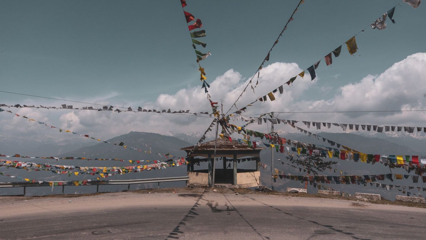
The Guwahati to Tawang distance is roughly 480 km by road, according to the Tawang district administration, and the drive takes about 14 to 16 hours. Most travellers split it over two days, with a night in Dirang or Bomdila. The route runs Guwahati–Tezpur–Bhalukpong–Bomdila–Dirang–Sela Pass–Jang–Tawang, and it now uses the Sela Tunnel, opened in March 2024.
Tawang sits at about 3,000 m in western Arunachal Pradesh, close to the border with Bhutan and Tibet. Over this Guwahati to Tawang distance, the road climbs from the Assam plains at under 100 m to Sela Pass at more than 4,000 m. You also need an Arunachal Inner Line Permit, which staff check at Bhalukpong.
Key takeaways
- The Guwahati to Tawang distance is about 480 km; route variations give readings of roughly 440 to 520 km.
- Driving time is usually 14 to 16 hours, so plan two days each way.
- Indian tourists need an Arunachal eILP, checked at Bhalukpong.
- The Sela Tunnel, opened on 9 March 2024, gives all-weather access below Sela Pass.
- A state-run helicopter service links Guwahati and Tawang in about an hour, subject to weather.
Guwahati to Tawang distance at a glance
| Detail | Information |
|---|---|
| Guwahati to Tawang distance | About 480 km (roughly 440 to 520 km by route) |
| Driving time | About 14 to 16 hours |
| Recommended split | 2 days, night halt in Dirang or Bomdila |
| Main route | Guwahati–Tezpur–Bhalukpong–Bomdila–Dirang–Sela–Tawang |
| Highest point | Sela Pass, a little over 4,100 m |
| Key new road work | Sela Tunnel (2024), Nechiphu Tunnel (2023) |
| Permit | Arunachal tourist eILP, ₹300 to ₹500 |
| Permit check | Bhalukpong check gate |
| Helicopter time | About 55 to 70 minutes |
| Nearest railhead to the hills | Rangapara North or Bhalukpong |
Why the Guwahati to Tawang distance takes so long
On paper, a Guwahati to Tawang distance of 480 km should take about eight hours. However, most of the road after Bhalukpong runs through steep hills. Hairpin bends, road works, army convoys and landslides all slow traffic. Furthermore, the climb to Sela Pass adds cold and occasional snow.
The first stretch from Guwahati to Tezpur is on plains and moves fast. In contrast, the mountain section from Bhalukpong to Tawang covers less than 300 km but takes most of the travel time. Therefore, average speeds in the hills often drop to around 25 to 30 km per hour.
The Tawang district administration also advises an overnight halt in Bomdila or Dirang. The reason is acclimatisation, since the jump in height is large. As a result, a one-day dash is possible but rarely wise.
Guwahati to Tawang distance: stage by stage
The table below shows approximate distances for each leg. Figures differ slightly between maps, state tourism pages and travel blogs, so treat them as guides.
| Stage | Approx. distance | Approx. time | Notes |
|---|---|---|---|
| Guwahati to Tezpur | About 180 km | 4 to 5 hours | Plains; good highway |
| Tezpur to Bhalukpong | About 56 to 60 km | 1.5 to 2 hours | Arunachal ILP check gate |
| Bhalukpong to Bomdila | About 100 to 110 km | 4 to 5 hours | Steady climb through forest |
| Bomdila to Dirang | About 42 km | 1.5 to 2 hours | Descent into Dirang valley |
| Dirang to Tawang | About 125 to 135 km | 4 to 6 hours | Sela Tunnel, Jang and final climb |
Added together, these legs put the Guwahati to Tawang distance in the region of 480 to 520 km. The exact figure depends on your start point in Guwahati and the road you take. Meanwhile, the district administration lists Tezpur to Tawang as about 330 km.
The Guwahati to Tawang route explained
Guwahati to Tezpur
Leave Guwahati early, ideally by 6 am, because the plains cover only a third of the Guwahati to Tawang distance. The road heads east along the north bank of the Brahmaputra towards Tezpur. Tezpur has hotels, fuel and food, and it is the main hub for shared vehicles to Tawang.
Tezpur to Bhalukpong
From Tezpur, the road goes north through Balipara to Bhalukpong on the Assam–Arunachal border. Bhalukpong sits at about 213 m beside the Kameng river. Here, staff check your Arunachal ILP, so keep printed copies ready.
Bhalukpong to Bomdila
After Bhalukpong, the real climb begins. The road passes Tipi, known for its orchid centre, and continues through thick forest. Additionally, the 500 m Nechiphu Tunnel, dedicated in 2023, now bypasses a fog-prone stretch before Bomdila.
Bomdila to Dirang
Bomdila is a hill town with monasteries and market views, at roughly 2,400 m. From there, the road drops to Dirang, a lower valley with apple orchards, hot springs and a fortified old village. Dirang is the most popular night halt.
Dirang to Tawang via Sela
The second day starts early. The road climbs towards Sela, where the new Sela Tunnel now carries traffic under the pass. After that, you descend to Jaswantgarh, Jang and the Nuranang Falls area. Finally, the road climbs again into Tawang.
Sela Tunnel and new roads in 2026
Prime Minister Narendra Modi dedicated the Sela Tunnel to the nation on 9 March 2024. The Border Roads Organisation built it at a cost of about ₹825 crore, according to PIB. It sits at about 13,000 ft and provides all-weather access to Tawang.
| Feature | Detail |
|---|---|
| Opened | 9 March 2024 |
| Built by | Border Roads Organisation |
| Cost | About ₹825 crore |
| Tunnel 1 | About 980 m, single tube |
| Tunnel 2 | About 1,555 m, twin tube with escape tube |
| Link road | About 1.2 km |
| Benefit | All-weather route; roughly 10 km and up to an hour saved |
Before the tunnel, heavy snow on Sela Pass often cut Tawang off for days, whatever the Guwahati to Tawang distance on the map. Now, traffic can keep moving in most winter weather. However, travellers still drive up to Sela Pass itself for the lake and views, weather permitting.
Road conditions change quickly in the hills. Check local advisories and ask your hotel or driver about landslides or snow before leaving each morning.
Transport options for the Guwahati to Tawang distance
You have four realistic ways to cover the Guwahati to Tawang distance. Each suits a different budget and timeline.
| Option | Typical time | Rough cost | Best for |
|---|---|---|---|
| Private taxi | 2 days | Highest; varies by vehicle and season | Families and groups |
| Shared Sumo from Tezpur | 12 to 16 hours from Tezpur | About ₹1,000 to ₹1,200 per seat (confirm locally) | Budget travellers |
| Bus | Long; often overnight or multi-stage | Low | Very tight budgets |
| Helicopter | About 1 hour | A few thousand rupees per seat | Travellers short on time |
Private taxi
Most visitors hire a cab from Guwahati to cover the full Guwahati to Tawang distance. Drivers usually know the permit routine and the best halts. Rates depend on the vehicle, the season and the number of days. Therefore, get written quotes that include the driver’s night charges.
Shared Sumo from Tezpur
Shared Sumos to Tawang leave Tezpur early in the morning, usually between about 5 am and 7 am. They reach Tawang late in the evening. Travel blogs report fares of around ₹1,000 to ₹1,100 a few years ago. However, fares change, so confirm the price at the counter a day ahead.
Bus
Assam and Arunachal state transport buses run on parts of the route, mostly from Tezpur to Bomdila, Dirang or Tawang. Direct buses from Guwahati are occasional and very long. As a result, most budget travellers combine a bus to Tezpur with a Sumo onwards.
Helicopter
Arunachal’s Civil Aviation Department runs a helicopter service between Guwahati and Tawang, usually from Monday to Saturday. The flight takes about an hour. Seats are limited, baggage is capped at about 10 kg, and weather often causes cancellations. Moreover, check the department’s current fare and booking counter before planning around it.
Arunachal ILP for the Guwahati to Tawang trip
Indian citizens from outside Arunachal Pradesh need an Inner Line Permit. Apply online for the tourist eILP on the official state portal before you travel. Our Arunachal ILP guide explains each step in detail.
| Tourist eILP | Fee | Notes |
|---|---|---|
| Up to 3 days | ₹300 per person | Too short for most Tawang trips |
| 4 to 14 days | ₹500 per person | Suits a normal Tawang itinerary |
Select Bhalukpong as your entry point if you are driving via Tezpur, since the gate sits roughly 240 km into the Guwahati to Tawang distance. Additionally, carry printouts and the original ID used in the application. For a wider view of permits across the region, see our inner line permit guide.
Visits to Bum La and some border lakes need an extra permit from the district authorities in Tawang. Your hotel or driver can usually help arrange it.
Guwahati to Tawang distance compared with other gateways
Guwahati is not the only starting point. The Tawang district administration lists distances from three airports, and they all join the same mountain road at Bhalukpong.
| Starting point | Approx. road distance to Tawang | Approx. drive time | Notes |
|---|---|---|---|
| Guwahati (LGBI airport) | About 480 km | 14 to 16 hours | Most flights and most taxis |
| Itanagar (Hollongi airport) | About 440 km | 12 to 15 hours | Via Gohpur or Banderdewa, then Tezpur bypass |
| Tezpur (Salonibari airport) | About 330 km | 10 to 12 hours | Fewer flights, shorter drive |
Tezpur saves roughly 150 km compared with the full Guwahati to Tawang distance. However, Tezpur has limited flights, so most visitors still land in Guwahati. Similarly, Itanagar suits travellers already touring central Arunachal. By rail, Rangapara North and Bhalukpong stations sit closer to the hills, but services are few. If your trip also covers Meghalaya, our Guwahati to Shillong distance guide helps you plan that leg.
Suggested two-day and three-day plans
Splitting the Guwahati to Tawang distance well makes the whole trip safer and more enjoyable.
| Plan | Day 1 | Day 2 | Day 3 |
|---|---|---|---|
| 2 days | Guwahati to Dirang (about 350 km) | Dirang to Tawang via Sela Tunnel | — |
| 3 days | Guwahati to Bhalukpong or Tezpur | Bhalukpong to Dirang, with Bomdila stop | Dirang to Tawang via Sela Pass |
| Return | Tawang to Dirang or Bomdila | Dirang or Bomdila to Guwahati | — |
The three-day plan suits families, elderly travellers and anyone sensitive to altitude. In contrast, the two-day plan works for fit travellers who start early each day.
Best time to drive the Guwahati to Tawang distance
March to May and October to early December usually offer the clearest roads. Spring brings rhododendrons, while autumn brings sharp mountain views. The Torgya festival and winter snow draw visitors from December to February, but cold nights are severe.
The monsoon, from about June to September, brings landslides and delays on the hill section of the Guwahati to Tawang distance. Therefore, keep a buffer day if you travel then. Plan the season with our best time to visit Northeast India guide.
Road trip tips and common mistakes
- Start before dawn on both days, as hill roads slow down after noon.
- Carry warm layers, since Sela can be freezing even in October.
- Keep cash, because ATMs and card machines can fail in smaller towns.
- Carry motion-sickness remedies and drink plenty of water at height.
- Do not self-drive after dark on unfamiliar mountain roads.
- Fill fuel at Tezpur, Bomdila or Dirang when you can.
- Do not rely on the helicopter without a backup road plan.
Most of these mistakes cost time rather than money. Nevertheless, on a Guwahati to Tawang distance this long, a lost hour can push the drive into darkness. Many visitors also ask about the region’s old name. Tawang was once part of the North-East Frontier Agency; read our explainer on the NEFA full form.
Frequently asked questions
What is the Guwahati to Tawang distance by road?
The Guwahati to Tawang distance is about 480 km by road, according to the Tawang district administration. Map apps and travel guides give figures between roughly 440 and 520 km, depending on the start point and road used. The main route passes Tezpur, Bhalukpong, Bomdila, Dirang, the Sela Tunnel and Jang before reaching Tawang.
How many hours does it take to drive from Guwahati to Tawang?
The Guwahati to Tawang distance usually takes 14 to 16 hours of actual driving. Most people split it across two days with a night in Dirang or Bomdila. Hill traffic, road works, convoys and weather can add several hours. Therefore, start early each morning and avoid planning a same-day return or tight connections.
Can I travel from Guwahati to Tawang in one day?
Covering the Guwahati to Tawang distance in one day is possible for a fit driver who leaves before dawn. However, it is tiring and gives no time to adjust to altitude. The Tawang district administration advises an overnight stop in Bomdila or Dirang. A two-day journey is safer, more comfortable and lets you enjoy the views.
Is the Sela Tunnel open to tourists?
Yes. The Sela Tunnel was dedicated to the nation on 9 March 2024 and carries regular traffic between Dirang and Tawang. It provides all-weather connectivity below Sela Pass. Tourists still visit the pass itself for its lake and views when the road is clear. Always check local advisories in heavy snow.
Do I need a permit to travel from Guwahati to Tawang?
Yes. Indian tourists from outside Arunachal Pradesh need a tourist eILP, which costs ₹300 for up to three days or ₹500 for up to 14 days. Staff check it at the Bhalukpong gate. Visits to Bum La and some border areas need an additional local permit arranged in Tawang.
Is there a helicopter from Guwahati to Tawang?
Yes. Arunachal’s Civil Aviation Department runs a helicopter service between Guwahati and Tawang, usually from Monday to Saturday. The flight covers the Guwahati to Tawang distance in about an hour and allows only light baggage. Seats are few, and weather or official requirements can cancel flights. Confirm the current fare and schedule directly with the department before booking.
What is the cheapest way to reach Tawang from Guwahati?
The cheapest option is a bus or shared jeep from Guwahati to Tezpur, followed by a shared Sumo to Tawang. Sumos leave Tezpur early in the morning and reach Tawang by evening. Fares are modest, often around ₹1,000 or more per seat, but confirm the current price at the Tezpur counter.
Plan the Guwahati to Tawang drive with confidence
The Guwahati to Tawang distance is long, but the road rewards patience at every bend. Budget two days, secure your eILP early and let the Sela Tunnel ease the final climb. To place Arunachal Pradesh in the wider region, read about the Seven Sisters of India.
Find more route and permit guides in Permits & Routes or visit the Frontier News homepage.
Related guides
More in Permits & Routes →
Permits & Routes
Sikkim Permit Guide: Nathula, Tsomgo, North Sikkim and Zuluk
Permits & Routes
Guwahati to Shillong Distance, Routes, Taxi Fares and Travel Time
Permits & Routes