Mechuka Travel Guide 2026: How to Reach, Permits and Stays
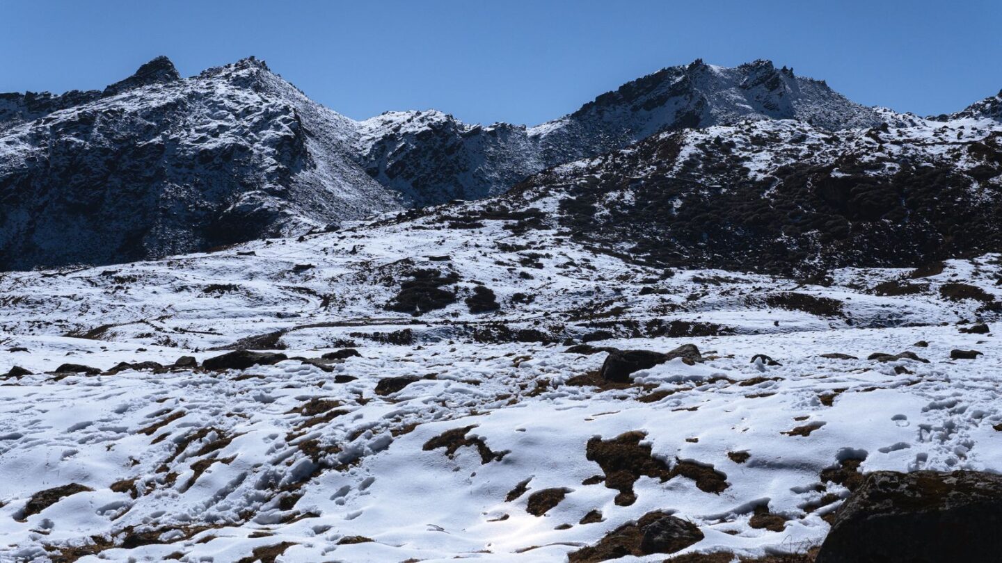
Mechuka (also spelt Mechukha or Menchukha) is a remote valley town in Arunachal Pradesh’s Shi Yomi district, set at about 1,890 m on the Siyom river. It lies roughly 180–190 km north of Aalo by a slow mountain road. Indian visitors need an Arunachal tourist eILP (₹300 for up to 3 days or ₹500 for up to 14 days), and most people stay in family-run homestays.
The valley sits close to the McMahon Line, with snow peaks on its northern rim. The Memba community, whose culture links to Tibetan Buddhism, lives here alongside Adi groups such as the Ramo, Bokar and Libo. As a result, the valley offers monasteries, pine meadows and village life that few Indian tourists have seen.
Key takeaways
- The town stands at about 1,890 m, according to the Shi Yomi district website.
- The usual road route runs Dibrugarh or Pasighat to Aalo, then about 180–190 km to the valley.
- A state-run helicopter links Naharlagun, Pasighat, Aalo and Menchuka on Mondays and Fridays, weather permitting.
- Indian tourists need an Arunachal eILP; foreign nationals need a Protected Area Permit.
- October to April is usually the best period, while the monsoon brings frequent landslides.
Mechuka at a glance
| Detail | Information |
|---|---|
| State and district | Arunachal Pradesh, Shi Yomi district (headquarters Tato) |
| Altitude | About 1,890 m (roughly 6,000 ft) |
| River | Siyom, known locally as Yargyap Chu |
| Nearest town | Aalo (Along), about 180–190 km south |
| Nearest airport | Dibrugarh (Mohanbari), roughly 380–430 km by road |
| Nearest railway stations | Silapathar, Murkongselek or Naharlagun |
| Permit for Indians | Arunachal tourist eILP, ₹300 or ₹500 |
| Permit for foreigners | Protected Area Permit (PAP) |
| Main communities | Memba, Ramo, Bokar, Libo and Tagin |
| Best time | October to April |
Where Mechuka is and what makes it different
The town lies in the upper Siyom valley in central Arunachal Pradesh. Shi Yomi district was carved out of West Siang in December 2018. Its headquarters is Tato, which sits on the road between Aalo and Mechuka.
The district website explains the name through three local words. “Men” means medicinal, “chu” means water and “kha” means snow or ice. Therefore, the name loosely translates as the valley of medicinal water and snow.
The landscape differs from most of Arunachal. Instead of steep jungle, you find a wide, flat valley floor with grass meadows, pine groves and a meandering river. Moreover, the snow ranges to the north stay visible on clear days. The town has a small market, a few government offices, an army presence and an airstrip run by the Indian Air Force.
The area once formed part of the old North-East Frontier Agency. Our explainer on the NEFA full form covers how that frontier tract became today’s Arunachal Pradesh.
How to reach Mechuka
There is no railway or scheduled airline service to the valley. Consequently, almost everyone arrives by road through Aalo, the West Siang district headquarters. Plan for two full travel days from Dibrugarh or Guwahati.
| Starting point | Route | Approx. distance to Mechuka | Typical time |
|---|---|---|---|
| Dibrugarh | Bogibeel bridge, Likabali, Basar, Aalo | About 380–430 km | 11–14 hours, usually split at Aalo |
| Pasighat | Pasighat to Aalo, then Tato | About 280 km | 9–11 hours |
| Silapathar railhead | Likabali, Basar, Aalo | About 390 km | Two days with a night at Aalo |
| Itanagar | Via Ziro or Likabali to Aalo | About 450–490 km | Two days |
| Aalo | Kaying, Tato | About 180–190 km | 7–9 hours |
Distances vary between sources and depend on the exact road used. Additionally, landslide diversions can add hours. Therefore, treat these as planning figures, not promises.
By air
Dibrugarh’s Mohanbari airport is the most practical airport, with direct flights from Delhi, Kolkata and Guwahati. From there, a reserved SUV reaches Aalo in about five to six hours. Alternatively, Pasighat and Itanagar’s Donyi Polo airport can work for some itineraries.
By rail
Silapathar and Murkongselek in Assam, and Naharlagun near Itanagar, are the usual railheads. However, none of them has direct transport to the valley. You must first get to Aalo by shared taxi or private car.
By shared taxi
Shared Tata Sumos have long run on the Aalo–Mechuka route, leaving early in the morning. Travellers have reported departures around 5:30 am and a journey of about eight hours. Fares change often, so ask at the Aalo taxi stand the evening before and book a seat in advance.
By helicopter
The Arunachal Civil Aviation Department lists a helicopter service run by Sky One Airways. Its MI-172 flies Naharlagun–Pasighat–Aalo–Mechuka and back on Mondays and Fridays, leaving Naharlagun at 9:00 am. Baggage is limited to 10 kg per person. Moreover, flights are subject to weather, VIP movements and medical evacuations. Check the fare and booking numbers with the department before planning around it.
Mechuka permits: eILP for Indians and PAP for foreigners
Every Indian visitor from outside Arunachal Pradesh needs an Inner Line Permit. The valley is covered by the standard tourist eILP, so no separate district permit is usually needed. Apply on the official state eILP portal before you travel, and carry printed copies.
| Visitor | Permit needed | Fee | Notes |
|---|---|---|---|
| Indian tourist, up to 3 days | Tourist eILP | ₹300 | Too short for most trips here |
| Indian tourist, up to 14 days | Tourist eILP | ₹500 | Suits a normal itinerary |
| Resident of Arunachal Pradesh | None | Nil | Carry proof of residence |
| Foreign national | Protected Area Permit | Varies | Arrange through a registered operator |
Choose the 14-day permit, because the journey alone takes four days out of a typical trip. Our Arunachal ILP guide explains each step, photo rule and check gate. For the wider picture, see which states use the inner line permit in Northeast India.
Foreign nationals should expect stricter rules near the border. Some areas near the border may stay closed to them even with a PAP. Therefore, foreign visitors should confirm exact places with their operator before booking.
Mechuka road conditions in 2026
The Aalo–Mechuka road is the valley’s lifeline, and it remains a work in progress. The Border Roads Organisation, under Project Brahmank, is widening the stretches north of Aalo.
In May 2025, rain triggered 15 blockages between Tato and Kaying, The Arunachal Times reported. The road then reopened for light vehicles only. Furthermore, in August 2025 the BRO said it aimed to finish formation cutting on the 32 km Pene–Tato stretch by March 2026, although land acquisition had caused delays.
In practice, expect a mix of new blacktop, broken patches and active construction zones. As a result, a high-clearance SUV with a local driver is the safest choice. Avoid driving after dark, as the Incredible India page also advises. During the monsoon, build at least one spare day into your plan.
Before leaving Aalo, ask your driver or homestay host about blockages beyond Tato. Road status on this route can change within hours during heavy rain.
Things to do in Mechuka
Most sights lie within a short drive of the town. Hire a local vehicle for a day, or walk the meadows along the river.
| Place | What it is | Notes |
|---|---|---|
| Samten Yongcha Monastery | Hilltop Mahayana gompa, described as about 400 years old | Views over the whole valley |
| Dzogchen Samten Choeling | Newer monastery near the town | Active prayer halls |
| Guru Nanak Taposthan | Gurudwara linked by tradition to Guru Nanak’s travels | Open to visitors of all faiths |
| Hanuman Point (Hanuman Camp) | Rock formation likened to Hanuman’s face | About 7 km from town |
| Siyom riverside | Meadows and pine groves on the valley floor | Good for walks and picnics |
| Dorjeeling village | Village of wooden houses, farms and grazing horses | Short drive from town |
| Siko Dido area | Waterfall area near the valley’s long zipline | Zipline reported at over 800 m |
| Mechuka Adventure Park | Adventure activities near town | Opened in March 2024 |
Several blogs mention high lakes and longer treks towards the border. However, these need a local guide, porters and, for some areas, army clearance. Ask at your homestay or the district tourism office before planning one.
Mechuka culture: the Memba people and Samten Yongcha
The Memba are a Buddhist community who speak a language related to Tibetan. Historically, they traded across the passes into Tibet. Their homes, prayer flags and chortens give the valley a Himalayan Buddhist character.
In contrast, the Ramo, Bokar and Libo belong to the wider Adi group, and the Tagin also live in parts of the district. Consequently, the valley mixes Buddhist and Donyi-Polo traditions in one small valley.
Samten Yongcha is the spiritual centre. Incredible India describes it as a 400-year-old Mahayana monastery with old scripts and statues. Losar, the Buddhist new year, is celebrated there, usually in February or March. Dress modestly, walk clockwise around shrines and ask before photographing monks.
Mechuka in the 1962 war
Mechuka has a significant place in the 1962 India–China war. A USI of India study puts the garrison at roughly 850 troops, including 2/8 Gorkha Rifles, a Madras company and Assam Rifles platoons. Chinese troops made contact at Nisangong on 17 November 1962.
Indian commanders then ordered a withdrawal. The garrison vacated Menchuka on the night of 18–19 November, and Chinese forces occupied it by the next morning. The retreat through the mountains cost many lives. Meanwhile, China declared a ceasefire on 21 November and later pulled back.
Today, the Indian Air Force’s Advanced Landing Ground reflects the area’s strategic role. It was upgraded to a 4,700 ft concrete runway in 2017. For another frontier story from the same war, see our Tawang travel guide.
Best time to visit Mechuka
October to April usually brings the clearest skies. However, each season offers something different.
| Months | Weather | Road and travel | Good for |
|---|---|---|---|
| October–November | Clear, cool days, cold nights | Best road conditions of the year | Views, photography, autumn colours |
| December–February | Very cold; snow on peaks, sometimes in the valley | Open, but ice possible at dawn | Snow scenes, quiet homestays |
| March–April | Mild days, spring flowers | Generally fine; early showers | Walks, Losar season |
| May | Warming, rain increases | Landslide risk rises | Green meadows |
| June–September | Monsoon, heavy rain | Frequent blockages | Not recommended |
The Adventure@Mechuka festival, organised by the district administration, has in past years been held in late November. In April 2025, the valley also hosted a four-day adventure race covering about 150 km. Dates change from year to year, so check with Shi Yomi district tourism for 2026 events. For season planning across the region, read our best time to visit Northeast India guide.
Where to stay in Mechuka and what it costs
Homestays form the backbone of local tourism. Most are run by Memba or Adi families, and meals usually come included or at a small extra cost. A few small hotels and government guest houses also exist, but the latter need advance booking.
| Item | Typical cost | Notes |
|---|---|---|
| Arunachal tourist eILP | ₹300 or ₹500 | Official state fee |
| Homestay double room | Roughly ₹800–₹2,500 per night | Higher in peak weeks |
| Homestay meals | Often included, or ₹200–₹500 per day | Ask when booking |
| Local sightseeing vehicle | Negotiated per day | Fix the route beforehand |
| Reserved SUV Dibrugarh–Mechuka | Several thousand rupees each way | Varies with season and car |
These are indicative ranges from travel reports, not fixed tariffs. Therefore, confirm the price, heating and hot water directly with your host. Book ahead for October, November and festival dates, as rooms fill quickly.
Sample 6-day Mechuka itinerary from Dibrugarh
This plan assumes a reserved SUV. It keeps travel days short enough for daylight driving.
| Day | Route or activity | Overnight |
|---|---|---|
| 1 | Dibrugarh to Aalo via Bogibeel bridge (about 190 km) | Aalo |
| 2 | Aalo to Mechuka via Kaying and Tato | Homestay in town |
| 3 | Samten Yongcha, riverside meadows, town market | Homestay in town |
| 4 | Hanuman Point, Dorjeeling, Guru Nanak Taposthan | Homestay in town |
| 5 | Return drive to Aalo | Aalo |
| 6 | Aalo to Dibrugarh for the flight home | Dibrugarh |
Add one buffer day in any season. Similarly, add a night in Pasighat if you want to see the Siang river.
Practical tips for a Mechuka trip
- Carry cash: ATMs have historically been scarce or unreliable, so draw money in Dibrugarh or Aalo.
- Expect weak networks: coverage beyond Aalo is limited; download maps and bookings offline.
- Pack warm layers: nights stay cold even in October, and winter drops below freezing.
- Respect army areas: do not photograph military installations or the airstrip.
- Keep ID handy: check posts may ask for your eILP and original photo ID.
- Travel by daylight: start early and reach your stop before dark.
The valley remains one of the least visited corners of the Seven Sisters. Our overview of the Seven Sisters of India shows how Arunachal fits into the region.
Frequently asked questions
Do I need a permit to visit Mechuka?
Yes. Indian citizens from outside Arunachal Pradesh need a tourist eILP, which costs ₹300 for up to 3 days or ₹500 for up to 14 days. Apply online on the official state portal and carry printed copies. Foreign nationals need a Protected Area Permit instead, usually arranged through a registered tour operator.
How far is Mechuka from Aalo?
Mechuka lies roughly 180–190 km north of Aalo, the West Siang headquarters. The drive usually takes seven to nine hours on a mountain road through Kaying and Tato. Road works and landslides can add several hours. Therefore, start early in the morning and avoid finishing the journey after dark.
What is the altitude of Mechuka?
The Shi Yomi district website puts the town at about 1,890 m. Other sources round this to roughly 6,000 ft. The town sits on the valley floor, while the surrounding ridges and peaks rise much higher. Most visitors do not face serious altitude problems, but nights can be very cold in winter.
Is there a flight to Mechuka?
There is no scheduled airline flight to Mechuka. However, the state’s subsidised helicopter service links Naharlagun, Pasighat, Aalo and Menchuka on Mondays and Fridays, according to the Arunachal Civil Aviation Department. Seats are limited and weather often causes cancellations. Most travellers therefore fly into Dibrugarh and continue by road.
Does Mechuka get snowfall?
The peaks around the valley carry snow for much of the winter. The valley floor sometimes gets snow between December and February, but it does not happen every year. If snow is your main goal, keep dates flexible. In any case, pack heavy woollens, gloves and thermal wear for winter visits.
How many days do you need for Mechuka?
Plan at least five to six days from Dibrugarh. Two days go to the journey in, two to the return, and you need one or two days in the valley. Adding a buffer day is sensible because landslides and weather can delay the road or the helicopter at short notice.
Is Mechuka safe for tourists?
The valley is generally considered safe, and homestay hosts are used to visitors. The main risks come from the road, weather and cold rather than crime. Travel in daylight, use experienced local drivers and keep your permit and ID with you. Also follow army instructions near restricted areas.
Planning your Mechuka valley trip
Mechuka rewards travellers who accept long drives and flexible plans. Get your eILP, carry cash and warm clothes, and allow buffer days for the road. In return, you get monasteries, Memba villages and wide river meadows under snow peaks.
Find more destination guides in Northeast Travel or visit the Frontier News homepage.
Related guides
More in Northeast Travel →
Northeast Travel
Laitlum Canyon Guide: How to Reach, Rasong Trek and Best Time
Northeast Travel
Yumthang Valley: Valley of Flowers, Permit, Route and Best Time
Northeast Travel