Zuluk Travel Guide 2026: Silk Route, Permit and Loops
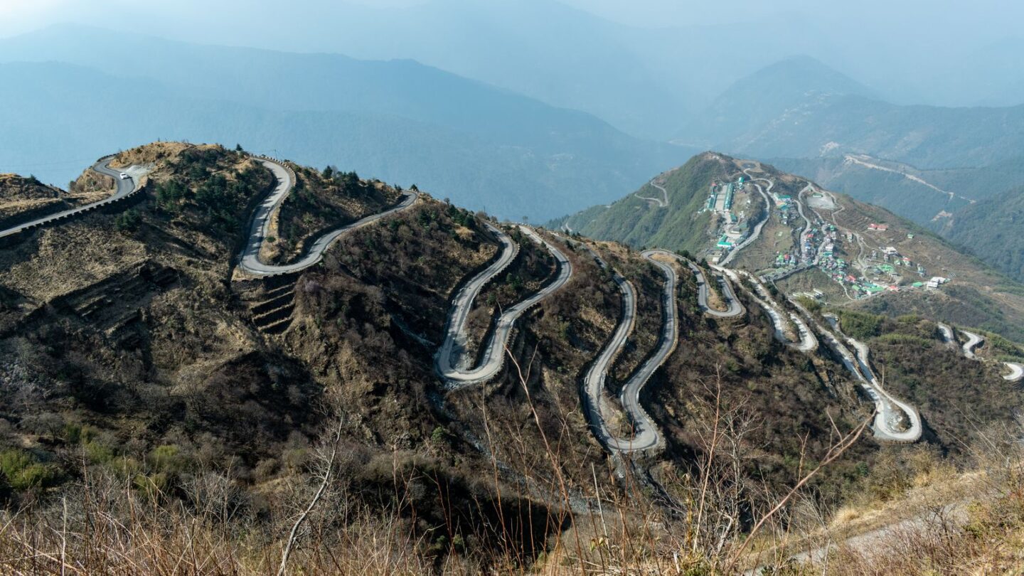
Zuluk (also spelt Dzuluk) is a small army-and-homestay village on the Old Silk Route in East Sikkim, at roughly 2,850–3,000 m. It lies about 90 km from Gangtok and about 35 km above Rongli, where Indian visitors usually get the mandatory Protected Area Permit. Foreign nationals cannot visit, and most travellers come for the zig-zag road loops and sunrise views of Kanchenjunga.
The village sits in Pakyong district on the historic trade route that once ran from Kalimpong to Tibet over the Jelep La. Today, the Border Roads Organisation keeps the road open because it serves army posts near the China border. As a result, the drive is the main attraction, and the village itself is a quiet overnight base. This guide covers the permit, routes, loops, stays, seasons and the most common planning mistakes.
Key takeaways
- The village sits at roughly 2,850–3,000 m in Pakyong district, East Sikkim.
- Indians need a Protected Area Permit, usually arranged at Rongli or through a Gangtok operator.
- Aadhaar is not accepted for the permit, and foreign nationals are not allowed.
- The famous loops are best seen from Thambi viewpoint and the road towards Lungthung.
- Stays are homestays only, and there is no ATM in the village.
Zuluk at a glance
| Detail | Information |
|---|---|
| Other spelling | Dzuluk |
| Location | Pakyong district, East Sikkim, on the Old Silk Route |
| Altitude | Roughly 2,850–3,000 m (about 9,400–10,000 ft); sources differ |
| Distance from Gangtok | About 90 km, usually 3–4 hours or more |
| Distance from Rongli | About 35 km, around 1.5 hours |
| Permit | Protected Area Permit for Indians; foreigners not allowed |
| Permit office | Rongli, or a registered Gangtok operator |
| Accepted ID | Passport, voter ID, driving licence, government ID (not Aadhaar) |
| Stay | Family-run homestays |
| Best months | Mid-April to June and October to November |
Zuluk and the history of the Old Silk Route
For generations, mule caravans carried goods such as wool between Tibet and Kalimpong. The route crossed the Jelep La, and villages such as Rongli and Zuluk served as halts. Trade dwindled after 1959, and the Jelep La has stayed closed since the 1962 war.
Some former traders and porters stayed behind and settled. Consequently, a small village grew up here; a census count put it at about 300 residents in 65 households. Meanwhile, the Indian Army set up a transit camp here. Furthermore, the road now forms part of National Highway 717B between Rhenock and Menla. The army presence explains the permit rules, the check posts and the good road surface.
Tourism came much later. However, the loops have since become famous on social media. In June 2026, these hairpin bends won the Most Instagrammable Landscape award at the India Today Tourism Survey and Awards.
Zuluk permit: rules for Indians and foreigners
The whole corridor from Lingtam upwards falls under protected-area rules. The Sikkim Tourism and Civil Aviation Department lists the Zuluk–Kupup axis, called the RN Road, among its PAP zones. Therefore, every Indian visitor needs a Protected Area Permit before crossing the check posts.
| Traveller | Can visit Zuluk? | Notes |
|---|---|---|
| Indian citizen | Yes | PAP through Rongli or a registered operator |
| Sikkim resident | Yes | Carry valid ID at check posts |
| Foreign national | No | Not permitted in this border zone |
| OCI cardholder | Treat as foreign | Sikkim applies foreigner rules to OCI holders |
| Children | Yes, with papers | Carry a birth certificate or passport |
Our Sikkim permit guide explains how this PAP fits with the Tsomgo, Nathula and North Sikkim permits. Moreover, it covers the online permit rules for foreign visitors.
Documents for the permit
The state tourism department says Aadhaar is not valid for permit processing. Instead, carry one of the documents below, plus photos.
| Document | Accepted? | Tip |
|---|---|---|
| Passport | Yes | Best choice for adults |
| Voter ID card | Yes | Widely used |
| Driving licence | Yes | Must be valid |
| Central or state government ID | Yes | Carry the original |
| Aadhaar card | No | Not accepted for the PAP |
| PAN card | No | Not treated as valid photo ID |
| Birth certificate | For minors | Carry with a parent’s ID |
| Passport-size photos | Required | Carry at least two, plus spares |
Rongli offices commonly ask for extra photos and photocopies. Therefore, carry three or four photos and several copies of your ID per person.
How to get the Zuluk permit
- Book a Sikkim-registered vehicle through a homestay, a Rongli operator or a Gangtok agency.
- Send scans of every traveller’s photo ID and photos a few days in advance.
- Reach Rongli in the morning if the permit is being issued there.
- Your driver or host files the papers at the Rongli office.
- Wait for the pass, which can take a few hours on busy days.
- The driver carries the permit and shows it at each check post.
Travellers from Gangtok can also get the permit through a registered Gangtok operator, usually a day before travel. Additionally, some guides mention the 3rd Mile police check post as an issuing point. Processing fees are small, but they vary, so ask your operator for the current figure.
Zuluk distances and routes
Two main approaches reach the village. Most travellers from Siliguri or New Jalpaiguri drive via Rangpo and Rongli. In contrast, travellers based in Gangtok often use the same Rongli road or loop back over Kupup and Tsomgo when permits allow.
| Route | Approx. distance | Approx. time |
|---|---|---|
| Gangtok to Zuluk via Rongli | About 90 km | 3–4 hours or more |
| Rongli to Zuluk | About 35 km | Around 1.5 hours |
| Rangpo to Rongli | About 24 km | Under 1 hour |
| Gangtok to Rongli | About 69 km | Varies with road conditions |
| Siliguri or NJP to Zuluk | Varies by route | Around 6–7 hours |
Distances come from map tools and travel references, so treat them as a guide. Furthermore, road work and landslides can add hours. The nearest railway station is New Jalpaiguri, while Bagdogra and Pakyong are the nearest airports.
The classic Silk Route circuit
Many visitors combine the village with Aritar, Padamchen, Nathang and Kupup over three or four nights. The loop then either returns to Rongli or continues to Gangtok via Kupup and Tsomgo. However, the Tsomgo leg needs its own permit, so confirm the plan with your operator. See our Tsomgo Lake guide for that stretch.
Zuluk loops, Thambi viewpoint and Lungthung
The road above Zuluk climbs in tight switchbacks, often described as three levels of loops stacked on one slope. Travel guides commonly cite 32 hairpin bends on the most photographed stretch. Counts vary by source, however, depending on which section a writer includes.
Thambi viewpoint, at roughly 3,400 m, is the classic spot to photograph the whole zig-zag. The viewpoint sits higher on the road towards Nathang, so drivers stop here on the way up. Similarly, the stretch near Lungthung gives wide views across the valley. On clear mornings, both points look across to Kanchenjunga and neighbouring peaks.
Sunrise over Kanchenjunga
Sunrise is the main reason to stay the night. Drivers usually leave the village around 4:00–4:30 am to reach Thambi or Lungthung before first light. Sunrise times shift through the year, so agree the start time with your host. Clear skies are most likely from October to December and on early spring mornings.
Places to see around Zuluk
The upper Silk Route has several stops within a few hours of the village. Altitudes below are rounded from guidebook figures, which often differ.
| Place | Approx. altitude | What to see |
|---|---|---|
| Rongli | About 1,585 m | Permit town and old market |
| Padamchen | Lower than Zuluk | Forest homestays and first check posts |
| Dzuluk village | About 2,850–3,000 m | Village, army camp and homestays |
| Thambi viewpoint | About 3,400 m | Best view of the loops |
| Nathang (Gnathang) valley | About 4,100 m | High meadow, snow in winter, homestays |
| Kupup Lake | About 3,980 m | Small lake often called Elephant Lake |
| Old Baba Mandir | About 4,000 m or higher | Original shrine of Baba Harbhajan Singh |
Nathang valley is a wide, high plateau with a few homestays. It turns white in winter and green after the snow melts. Kupup Lake, meanwhile, gets its nickname from its shape. Nearby, the Yak Golf Course is often described as among the highest golf courses in the world.
Old Baba Mandir marks the original bunker shrine of Baba Harbhajan Singh. It differs from the newer Baba Mandir on the Nathula road. The Nathula border itself needs a separate permit, which our Nathula pass permit guide explains.
Best time to visit Zuluk
Weather shapes every Silk Route trip. The road stays open for much of the year, but snow and fog can shut higher sections.
| Months | Conditions | Verdict |
|---|---|---|
| March | Cold, patchy snow, clearing roads | Good if roads are open |
| April to June | Rhododendrons, mild days | Very good |
| July to September | Monsoon, fog, landslides | Risky; views often hidden |
| October to November | Clear skies, crisp air | Excellent for views |
| December to February | Heavy snow at Nathang and Kupup | Beautiful but unreliable |
Snow usually arrives from December, and upper roads are often blocked between January and March. For example, after heavy snowfall in April 2025, permits on the RN Road were restricted only up to Zuluk. Therefore, keep a buffer day in winter and spring. For a regional overview, read our best time to visit Northeast India guide.
Vehicle rules and costs on the Zuluk road
Only Sikkim-registered vehicles on a valid permit usually carry tourists into this zone. Private cars from other states are generally stopped at Rongli. Similarly, self-drive rental cars are not a normal option. The official rules do allow self-driven bikes on a PAP routed through a registered agency. Consequently, bikers should confirm the current process before arriving.
| Cost item | Typical range | Notes |
|---|---|---|
| Sikkim tourist fee | ₹50 per tourist | Collected by accommodation |
| Zuluk permit processing | Small; varies | Often included by the operator |
| Homestay with meals | Roughly ₹900–₹2,500 per person per night | Depends on season and room |
| Reserved vehicle | Varies widely | Ask for a quote by the day |
| Operator service charge | Varies | Ask for an itemised quote |
Homestay prices come from 2026 travel guides and operator listings. However, rates rise in October and during holiday weeks. Compare at least two quotes and confirm whether meals, heaters and the sunrise drive are included.
Stays and facilities in Zuluk
The village has no large hotels. Instead, families run homestays with simple rooms and home-cooked meals. Some offer geysers and Western toilets, while others use bucket hot water. Additionally, Nathang and Padamchen have homestays for travellers who want to split the altitude.
- Cash: there is no ATM in the village, so withdraw money in Gangtok, Siliguri or Rongli.
- Mobile network: coverage is patchy; BSNL is often reported as the most reliable.
- Power: cuts happen, so carry a power bank and a torch.
- Heating: nights are cold in every season, so ask about blankets or heaters.
- Food: meals are simple, and dinner is served early.
Zuluk itineraries
The loops and Nathang need at least one night at altitude. The sample plans below suit most travellers.
| Plan | Day-by-day outline |
|---|---|
| 2 days from Gangtok | Day 1: Gangtok to Zuluk via Rongli. Day 2: Sunrise at Thambi, Nathang, Kupup, return to Gangtok |
| 3 days from NJP | Day 1: NJP to Aritar or Padamchen. Day 2: Zuluk. Day 3: Sunrise, Nathang, Kupup, then Gangtok |
| 4 days Silk Route | Aritar, Padamchen, Zuluk and Nathang, one night each, then return via Rongli |
A slower plan also helps the body adjust. The village itself is moderate, but Nathang and Kupup climb above 3,900 m.
Common Zuluk trip mistakes
- Bringing only Aadhaar: it is not valid for the permit.
- Arriving at Rongli late: permit offices work best in the morning.
- Booking as a foreigner: foreign nationals cannot enter this border area.
- Driving an outside-state car: it usually cannot go beyond Rongli.
- Rushing to Kupup on day one: headaches and breathlessness are common at that height.
- Skipping winter checks: snow can close Nathang and Kupup at short notice.
For the wider permit picture across the region, see our inner line permit guide.
Frequently asked questions
What is the altitude of Zuluk?
Sources differ, but Zuluk sits at roughly 2,850–3,000 m, or about 9,400–10,000 ft. The village is much lower than the passes above it. Thambi viewpoint is around 3,400 m, while Nathang valley and Kupup Lake stand at roughly 4,000 m. Therefore, plan gradual stops and watch for altitude symptoms higher up.
Do Indians need a permit for Zuluk?
Yes. Indian citizens need a Protected Area Permit for the Zuluk–Kupup axis. Your homestay or a registered operator usually arranges it at Rongli, or a Gangtok agency files it a day ahead. Carry a passport, voter ID, driving licence or government ID, because Aadhaar is not accepted, plus several passport-size photos.
Can foreigners visit Zuluk?
No. Foreign nationals are not permitted in this area, which lies close to the China border. Sikkim treats OCI cardholders like foreigners for its Restricted Area Permit, so they should not plan this trip. Foreign visitors can still see Tsomgo Lake or Lachung with the correct permits arranged through a registered agency.
How many hairpin bends does the Zuluk road have?
Most travel guides cite 32 hairpin bends on the famous stretch above the village. However, counts vary depending on which section is included. The road climbs in three visible levels of loops. Thambi viewpoint and the road towards Lungthung give the best views of the full zig-zag.
How do I reach Zuluk from Siliguri or NJP?
Drive to Rangpo and then Rongli, where the permit is usually processed, and climb about 35 km to the village. The whole trip usually takes around six to seven hours. Only Sikkim-registered vehicles normally go beyond Rongli, so book a local taxi or package in advance.
Is Zuluk open in winter?
The village usually stays reachable, but snow from December often blocks Nathang, Kupup and the higher road. Closures are common between January and March, and permits can be limited at short notice. If you want snow, keep a buffer day, carry warm layers and confirm road status with your host.
Can I visit Zuluk and Nathula on one trip?
Yes, but you need separate permits. Nathula is a border pass that opens to Indian tourists on select days, while Zuluk falls under the RN Road permit. Many travellers finish the Silk Route in Gangtok and book Nathula as a separate day trip through a registered operator.
Plan your Zuluk loops with time to spare
Zuluk rewards travellers who plan the paperwork and give themselves a slow pace. Carry non-Aadhaar ID and spare photos, reach Rongli early and stay at least one night. Then save your best morning for Thambi, when the loops and Kanchenjunga line up at sunrise.
Explore more mountain routes in Northeast Travel or return to the Frontier News homepage.
Related guides
More in Northeast Travel →
Northeast Travel
Kamakhya Temple Guide 2026: Timings, Darshan and History
Northeast Travel
Mechuka Travel Guide 2026: How to Reach, Permits and Stays
Northeast Travel