Laitlum Canyon Guide: How to Reach, Rasong Trek and Best Time
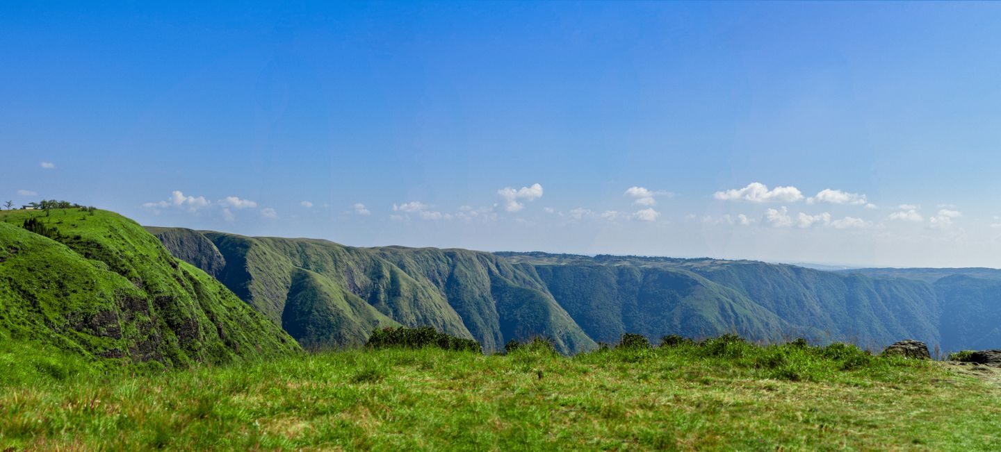
Laitlum canyon is a clifftop viewpoint in Meghalaya’s East Khasi Hills, about 24 to 25 km from Shillong by road, according to Meghalaya Tourism. The drive takes roughly 45 minutes to an hour via Smit village. From the edge, you look down into deep, forested gorges, and a long stone stairway leads to the valley village of Rasong.
The name Laitlum means “end of the hills” in Khasi, which suits a place where the plateau suddenly drops away. It has become one of the most popular short trips from Shillong. Consequently, the site now has parking, paid viewpoints, food stalls and homestays along the approach road.
Key takeaways
- Laitlum canyon lies about 24 to 25 km from Shillong, reached by road via Smit.
- The Shillong Times reported ₹50 for parking and ₹30 each for two paid viewpoints in April 2026.
- A stairway of roughly 3,000 steps leads down to Rasong village, according to travel accounts.
- October to May usually gives the clearest views; the monsoon brings heavy mist and rain.
- No local buses run directly to the site, so hire a taxi or join a day tour.
Laitlum canyon at a glance
| Detail | Information |
|---|---|
| Location | Near Smit, East Khasi Hills, Meghalaya |
| Distance from Shillong | About 24 to 25 km |
| Drive time from Shillong | Roughly 45 minutes to 1 hour |
| Distance from Guwahati | Roughly 125 km via Shillong |
| Meaning of name | “End of the hills” in Khasi |
| Typical fees (2026 reports) | ₹50 parking; ₹30 per paid viewpoint |
| Visiting hours | Daylight hours, roughly 6 am to 5 pm |
| Best season | October to May |
| Main trek | Stairway to Rasong village, about 3,000 steps |
| Permit | None needed for Indian or foreign tourists |
What makes Laitlum canyon special
The Shillong plateau ends abruptly here. Steep ridges fall away into narrow valleys, with small villages, streams and waterfalls far below. On clear days, the view stretches across layer after layer of hills.
Clouds are part of the attraction. They often drift up from the gorges and fill the valleys. Meghalaya Tourism notes that sunsets over the gorge are especially striking. However, the same clouds can hide the view completely, particularly in the morning.
The top of Laitlum canyon is a broad, grassy ridge rather than a single railing. Therefore, visitors spread out along several points. Some spots are open ground with sheer drops, so watch your step.
How to reach Laitlum canyon
Shillong is the base for almost every visit. The road runs south-east from the city towards Smit, the seat of the Khyrim Syiemship. From Smit, a narrower road continues for several kilometres to the canyon rim.
| Starting point | Approx. distance | Approx. time | Notes |
|---|---|---|---|
| Shillong (Police Bazar) | About 24 to 25 km | 45 minutes to 1 hour | Via Smit |
| Smit village | About 8 km | 15 to 20 minutes | Last large village on the way |
| Guwahati | Roughly 125 km | 3.5 to 4.5 hours | About 100 km to Shillong, then onwards |
| Shillong Airport (Umroi) | Roughly 50 km | About 1.5 hours | Via Shillong city |
| Sohra (Cherrapunji) | Roughly 70 to 80 km | 2 to 2.5 hours | Back through Shillong |
Distances vary slightly between sources, so treat these as guides. For the first leg of your journey, see our Guwahati to Shillong distance guide.
By taxi
Most visitors hire a taxi in Shillong for a half-day trip. Travel blogs quote roughly ₹1,000 to ₹2,000 for a return trip, depending on the vehicle and waiting time. Fares change with season and demand. Therefore, agree the price, waiting time and stops before you set off.
By self-drive or scooter
Rental cars and scooters are available in Shillong. The road is paved but narrow in places, with sharp bends after Smit. Additionally, fog can cut visibility suddenly, so drive slowly and use low beams.
By public transport
Meghalaya Tourism says no local buses go directly to Laitlum. Shared vehicles may run towards Smit, but onward transport is irregular. As a result, a hired taxi or a day tour is the practical choice.
Laitlum canyon entry fees and costs in 2026
Laitlum canyon has no single government ticket. Instead, local bodies and operators collect separate charges. A Shillong Times report from April 2026 described several toll points.
| Charge | Reported amount | Notes |
|---|---|---|
| Parking at entrance | ₹50 | Per vehicle |
| Sarain Laitlum View Point | ₹30 | Per person |
| Sipro Park area | ₹30 | Per person |
| Taxi from Shillong | Roughly ₹1,000 to ₹2,000 return | Varies by vehicle and season |
| Pony rides and snacks | Varies | Agree the price first |
These amounts can change without notice. Moreover, some older blogs still say entry is free, which is no longer accurate for the main viewpoints. Carry small notes and some cash, because card and UPI payment may not work everywhere.
The Rasong village trek
The most famous walk at Laitlum canyon is the descent to Rasong. The Better India describes this small village as home to about 300 people. A stairway of roughly 3,000 steps connects it to the ridge.
The path passes bamboo groves, ferns and orchids. Villagers have long used an old ropeway pulley to haul goods between the valley and the top. Meanwhile, residents grow broom grass and carry loads in traditional cane baskets.
| Trek detail | Approximate figure |
|---|---|
| Steps to Rasong | About 3,000 (travel accounts) |
| Descent time | Roughly 1 to 1.5 hours |
| Climb back up | Roughly 1.5 to 2.5 hours |
| Full walk with rest stops | Half a day or more |
| Difficulty | Moderate to hard, mainly the climb back |
| Guide | Recommended |
The way down feels easy. However, the return climb is steep and long, and it tests knees and lungs. Start early so you finish well before dark. Furthermore, Meghalaya Tourism advises arranging a local guide who knows the area and the language.
Other walks near the canyon
Meghalaya Tourism also mentions a scenic trek to Rai Um village. Shorter walks along the ridge give different angles on the gorge. Additionally, some visitors walk part of the way from Smit to enjoy the open hills.
Best time to visit Laitlum canyon
Weather decides whether you see a wide panorama or a wall of white cloud. Meghalaya Tourism names October to May as the best period for clear, pleasant views.
| Months | Weather | Views | Notes |
|---|---|---|---|
| October to November | Cool and mostly clear | Often the best | Nongkrem festival at Smit in autumn |
| December to February | Cold, dry, crisp | Good; morning haze possible | Carry warm layers |
| March to May | Mild, some showers | Good, with greener hills | Pre-monsoon storms in the afternoons |
| June to September | Heavy rain and thick mist | Often hidden | Slippery steps and roads |
Time of day matters as well. Mornings and evenings are often foggy, while late morning to mid-afternoon usually gives the clearest view. In contrast, visitors who come for sunset accept a higher chance of cloud. For a wider seasonal plan, see our guide on the best time to visit Northeast India.
Sunrise, sunset and photography at Laitlum canyon
Photographers come for sunrise and sunset, when the slopes turn soft pink and orange. However, fog is also most common at these hours. Therefore, plan a flexible slot and keep a second visit in mind if clouds roll in.
A wide-angle lens captures the scale of the gorge. Meanwhile, a short telephoto helps pick out Rasong’s roofs far below. Keep people and gear well back from the edge while shooting.
Drone flights fall under India’s national drone rules. Local councils or the police may also restrict flying. Therefore, ask locally before launching a drone, and never fly over homes or crowds.
Safety tips at the cliff edge
Laitlum canyon has sheer drops with little or no fencing at many points. Most accidents at viewpoints like this happen when visitors lean out for photos.
- Stay back from the edge, especially in wind, rain or fog.
- Do not climb rocks or step past barriers for selfies.
- Wear shoes with grip, because grass and steps turn slippery after rain.
- Keep children close at all times on the ridge.
- Carry water and a torch if you trek to Rasong.
- Start the return climb early, since daylight fades fast in winter.
Weather changes quickly on the Khasi Hills plateau. If thick fog rolls in, move away from the cliff edge and wait for it to clear.
Responsible travel at Laitlum canyon
Tourism has grown fast here. In March 2026, EastMojo reported concerns over plastic waste, animal dung from pony rides and loud music. The report also noted ongoing construction, and said ponies will not be allowed inside the Sipro Park area once work ends.
Visitors can reduce the pressure. Carry your rubbish back to Shillong, and avoid playing loud music. Moreover, buy snacks and tea from local stalls, which support village families. Always ask before photographing residents, and respect any rules the village councils put up.
Places to combine with Laitlum canyon
Laitlum canyon fits easily into a half-day, so pair it with nearby sights. The table lists common add-ons.
| Place | Approx. distance from Shillong | Why visit |
|---|---|---|
| Smit village | About 11 km | Khyrim palace, Ka Ing Sad, and the Nongkrem dance |
| Shillong Peak | About 10 km | City and valley views |
| Elephant Falls | About 12 km | Three-tier waterfall on the Sohra road |
| Mawphlang sacred forest | About 25 km | Protected Khasi sacred grove |
| Sohra (Cherrapunji) | About 55 km | Waterfalls, caves and root bridges |
| Dawki | About 95 km | Umngot river boating |
Smit sits on the way, so a stop there costs little time. The Meghalaya government notes that Smit hosts the five-day Nongkrem dance, generally in November. For longer trips, our guides to Cherrapunji and Dawki cover the classic southern routes.
Sample one-day plan from Shillong
| Time | Plan |
|---|---|
| Morning | Visit Shillong Peak or Elephant Falls |
| Late morning | Drive to Smit and see the Ing Sad palace from outside |
| Midday | Reach Laitlum canyon for the clearest views and lunch at a stall |
| Afternoon | Walk the ridge or descend part of the Rasong stairway |
| Evening | Return to Shillong before dark |
Permits and practical information
Meghalaya does not require an Inner Line Permit for Indian visitors, and foreign tourists need no special permit for Laitlum. Our inner line permit guide explains which Northeast states do.
Facilities have improved but remain basic. Expect parking, tea stalls, snack sellers, some restaurants and homestays along the Smit road. Toilets may carry a small charge. Mobile coverage is usually available near the top, but it can drop in the valley.
Common mistakes to avoid
- Arriving in thick morning fog without time to wait for it to lift.
- Underestimating the Rasong climb and starting it late in the day.
- Visiting only in peak monsoon and expecting clear views.
- Carrying no cash for parking and viewpoint fees.
- Going too close to the edge for photos.
- Leaving litter at a site already struggling with waste.
Frequently asked questions
How far is Laitlum canyon from Shillong?
Laitlum canyon is about 24 to 25 km from Shillong, according to Meghalaya Tourism. The drive takes roughly 45 minutes to an hour via Smit village, depending on traffic and fog. There are no direct local buses, so most visitors hire a taxi for a half-day return trip or join an organised day tour.
Is there an entry fee at Laitlum canyon?
There is no single government ticket, but local charges apply. In April 2026, the Shillong Times reported ₹50 for parking and ₹30 each for the Sarain Laitlum View Point and the Sipro Park area. Amounts can change, so carry small notes and some cash for these separate collection points.
How many steps lead down to Rasong village?
Travel accounts put the stairway to Rasong at roughly 3,000 steps. The descent usually takes about an hour, while the climb back is much harder and slower. Start early, carry water and wear shoes with good grip. A local guide is useful, because some paths branch off towards other villages and fields.
What is the best time to visit Laitlum canyon?
October to May is usually best, with October and November often giving the clearest skies. Late morning to mid-afternoon tends to offer better visibility than early morning or evening, when fog is common. The monsoon from June to September brings heavy rain and thick mist that can hide the gorge completely.
What does the name Laitlum mean?
Laitlum means “end of the hills” in Khasi. The name reflects the landscape, where the Shillong plateau ends suddenly at steep cliffs above deep valleys. Meghalaya Tourism and the Incredible India portal both use this meaning. The site is also called Laitlum Canyons or Laitlum Grand Canyon in many travel listings.
Is Laitlum canyon safe for children and older visitors?
The ridge viewpoints are safe for most visitors if they stay well back from the edge. Many points have sheer drops with little fencing, so keep children close at all times. The Rasong stairway is strenuous, particularly the return climb. Older visitors or anyone with limited stamina should stay on the ridge-top walks instead.
Can I visit Laitlum canyon and Cherrapunji on the same day?
It is possible but rushed, because both lie in different directions from Shillong. Laitlum sits about 24 km south-east of the city, while Sohra lies about 55 km to the south. A better plan pairs Laitlum with Smit, Shillong Peak or Elephant Falls, and keeps Sohra for a separate full day.
Plan a clear-weather trip to Laitlum canyon
Laitlum canyon rewards visitors who time it well. Go between October and May, aim for the middle of the day and keep cash for local fees. If you have the energy, the Rasong stairway shows a side of the Khasi Hills that few road trips reach. To see how Meghalaya fits into the wider region, read our guide to the Seven Sisters of India.
Explore more destination guides in Northeast Travel or visit the Frontier News homepage.
Related guides
More in Northeast Travel →
Northeast Travel
Yumthang Valley: Valley of Flowers, Permit, Route and Best Time
Northeast Travel
Kaziranga Safari Booking 2026: Jeep and Elephant Safari Guide
Northeast Travel