Cherrapunji (Sohra) Travel Guide: Waterfalls, Caves and Best Time
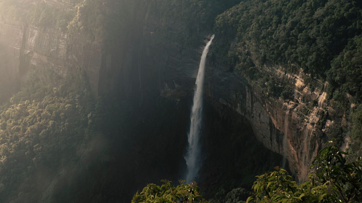
Cherrapunji, officially called Sohra, is a plateau town in Meghalaya’s East Khasi Hills, about 55 km south of Shillong. It is famous for world-record rainfall, tall plunge waterfalls such as Nohkalikai, limestone caves and the double-decker living root bridge at Nongriat. Most travellers visit on a day trip from Shillong, although one or two nights here give a far better experience.
The town sits at roughly 1,430 m on the southern edge of the Khasi Hills. Below it, the land drops steeply towards the plains of Bangladesh. As a result, monsoon clouds from the Bay of Bengal hit the cliffs and release huge amounts of rain. This guide covers the main sights, the Nongriat trek, entry fees, new local rules and the best months to go.
Key takeaways
- Cherrapunji (Sohra) is about 55 km from Shillong by road, usually a 1.5 to 2-hour drive.
- It holds the Guinness record for the most rain in one year: 26,470 mm between August 1860 and July 1861.
- Nohkalikai Falls drops about 340 m and is often called India’s tallest plunge waterfall.
- The double-decker root bridge at Nongriat needs a trek of about 3,500 steps down from Tyrna and back up.
- Since mid-2025, local guides are mandatory for trekking, and picnics and open cooking are banned along the Mawkdok–Sohra road.
Cherrapunji at a glance
| Detail | Information |
|---|---|
| Official name | Sohra |
| District | East Khasi Hills, Meghalaya |
| Altitude | About 1,430 m |
| Distance from Shillong | About 55 km (1.5–2 hours) |
| Nearest airport | Shillong (Umroi), about 79 km; Guwahati, about 167 km |
| Nearest major railhead | Guwahati |
| Famous for | Rainfall records, waterfalls, caves, living root bridges |
| Permit needed | No Inner Line Permit for Indian visitors |
| Ideal stay | 1–2 nights |
Meghalaya does not use the Inner Line Permit system. Therefore, Indian tourists can visit without a permit. For states that do require one, see our Inner Line Permit guide for Northeast India.
Why Cherrapunji is famous for rain
The town’s reputation rests on its rainfall records. According to Guinness World Records, 26,470 mm of rain fell at Cherrapunji between 1 August 1860 and 31 July 1861. That is still the record for the greatest rainfall in a single year. Moreover, July 1861 alone brought about 9,300 mm, which is also cited as a monthly record.
The cause is geography. Moisture-laden monsoon winds cross the flat plains of Bangladesh without much rain. However, when they meet the steep southern face of the Khasi Hills, they rise, cool and release their water.
Cherrapunji vs Mawsynram
Today, nearby Mawsynram is usually called the wettest place on Earth. Both towns record long-term averages of roughly 11,000 to 12,000 mm a year, and Mawsynram edges ahead. Nevertheless, Cherrapunji keeps the all-time single-year and single-month records.
| Point | Cherrapunji (Sohra) | Mawsynram |
|---|---|---|
| Average annual rainfall | Roughly 11,000–12,000 mm | Roughly 11,800–12,000 mm |
| Current “wettest place” title | No | Usually yes |
| All-time yearly record | Yes (1860–61) | No |
| Tourist infrastructure | Well developed | Limited |
| Distance from Shillong | About 55 km | About 60 km |
Rainfall figures vary by year and by weather station. Consequently, treat these averages as approximate.
Top waterfalls in Cherrapunji
Waterfalls are the main reason most people come to Cherrapunji. Their flow depends heavily on the season. In the monsoon, they roar; in late winter, some shrink to thin threads or dry up.
Nohkalikai Falls
Nohkalikai drops about 340 m in a single plunge into a green pool. Meghalaya Tourism places it about 7.5 km from Sohra town and lists viewing hours of 8 am to 5 pm. The name comes from a Khasi legend about a woman called Ka Likai. After a terrible family tragedy, she is said to have leapt from the cliff edge here. The main viewpoint has steps, stalls and railings. Additionally, a steep trail leads towards the pool, but you should attempt it only with a local guide.
Seven Sisters Falls (Nohsngithiang)
Also known as Mawsmai Falls, this waterfall splits into several streams across a wide limestone cliff. It drops more than 300 m and lies roughly 1 km south of Mawsmai village. It flows fully only in the rainy season, so June to September offers the best view. Late afternoon light from the viewpoint can also be striking. Note that this waterfall is different from the Seven Sisters of India, which is a name for the Northeast states.
Wah Kaba, Dainthlen and Wei Sawdong
Wah Kaba Falls is visible from a viewpoint on the Shillong–Sohra road, before you reach town. It falls roughly 170 to 190 m into a gorge. Dainthlen Falls, north-west of Sohra, links to the Khasi legend of the “thlen”, a giant serpent. Meanwhile, Wei Sawdong is a three-tiered fall a short drive from Dainthlen. It requires a steep descent on bamboo steps, so wear shoes with good grip.
Rainbow Falls
Rainbow Falls lies beyond the double-decker root bridge at Nongriat. It is reachable only on foot. On sunny mornings, spray at the base can form a rainbow, which gives the fall its name.
Caves near Cherrapunji
Sohra sits on limestone, so caves are common. However, some may close or flood during heavy rain, so check locally in the monsoon.
| Cave | What to expect | Approx. distance from Sohra |
|---|---|---|
| Mawsmai Cave | About 150 m lit section, stalactites, narrow squeezes | About 4–6 km |
| Arwah Cave | Forest walk, fossil shells and fish bones in the rock | About 3–5 km |
| Mawmluh Cave | Long, wild cave; guided exploration only | About 3–4 km |
| Garden of Caves | Landscaped caves, pools and small falls | About 15 km |
Mawsmai Cave
Mawsmai is the easiest cave in Cherrapunji for families. Meghalaya Tourism describes a lit route of about 150 m. It is manageable for beginners, although a few sections need bending and squeezing. Weekends can bring long queues, so arrive early.
Arwah Cave
Arwah involves a paved walk along Lawshynna hill with valley views. Inside, visitors can see fossilised crustacean shells and fish bones in the limestone walls. Similarly, the lit sections are short, so carry a torch for the darker corners.
Nongriat double-decker living root bridge trek
This is the most demanding and most rewarding part of a Cherrapunji trip. The Khasi people grow these bridges by guiding the roots of rubber fig trees across streams over many years. In 2022, the “Jingkieng Jri” living root bridge cultural landscapes joined India’s tentative list for UNESCO World Heritage status.
How the trek works
- Drive about 15 km from Sohra to Tyrna village, usually 30–45 minutes.
- Hire a registered local guide at the start, as guides are now mandatory for treks.
- Walk down about 3,500 stone steps to Nongriat, crossing small suspension bridges on the way.
- Allow roughly 2 hours down and a little longer to climb back up.
- Add around 1 hour each way if you continue to Rainbow Falls.
Start by 7 am if you plan to include Rainbow Falls. Otherwise, you may finish the climb in the dark. The steps are steep, so people with knee problems should think carefully. Alternatively, stay overnight at a simple homestay in Nongriat and climb back the next morning.
| Trek detail | Typical figure |
|---|---|
| Start point | Tyrna village |
| Steps | About 3,500 each way |
| Down to Nongriat | About 1.5–2 hours |
| Back up to Tyrna | About 2–2.5 hours |
| Nongriat to Rainbow Falls | About 1 hour each way |
| Entry and camera fees | Small village fees, usually under ₹100 in total |
Other places to see around Cherrapunji
- Mawkdok Dympep Valley: A viewpoint on the Shillong–Sohra road, roughly 30 km from Shillong. It overlooks a deep valley and offers zipline rides.
- Sohra Eco Park: A park on the cliff edge with views towards the Bangladesh plains and the Seven Sisters Falls.
- Thangkharang Park: A forested park with wide views over the plains and a greenhouse.
- Ramakrishna Mission, Sohra: A long-running mission with a small museum on local culture.
- Laitlum Canyons: A dramatic ridge viewpoint that many visitors pair with a Sohra trip, although it lies closer to Shillong.
Furthermore, many travellers continue from Sohra to the clear waters of Dawki and the Umngot River. That road passes through Pynursla and takes a few hours.
Cherrapunji entry fees and timings
Most Cherrapunji attractions charge small entry fees collected by the local village or Dorbar Shnong. These amounts change often and are not published on one official list. Therefore, the figures below are typical ranges reported by recent visitors, not official rates.
| Attraction | Typical entry fee | Usual hours |
|---|---|---|
| Nohkalikai Falls viewpoint | About ₹20–₹50 | 8 am–5 pm |
| Mawsmai Cave | About ₹20–₹50, plus camera fee | Around 9:30 am–5:30 pm |
| Arwah Cave | About ₹20–₹50 | Daytime only |
| Sohra Eco Park | About ₹20 | Daytime only |
| Dainthlen Falls | Parking fee around ₹20 | Daytime only |
| Double-decker root bridge | Small village fee | Daylight |
| Mawkdok zipline | About ₹400–₹800 | Weather dependent |
Carry cash in small notes, because card payments and UPI may not work everywhere. Additionally, parking often costs extra at each stop.
Best time to visit Cherrapunji
Each season shows a different side of Sohra. The right choice depends on what you want to see.
| Season | Months | What to expect |
|---|---|---|
| Pre-monsoon | March–May | Pleasant days, rising water flow, some rain showers |
| Monsoon | June–September | Waterfalls at their fullest; heavy rain, fog, slippery trails |
| Post-monsoon | October–November | Clear views, strong falls, good trekking weather |
| Winter | December–February | Cool, dry and clear; some falls shrink sharply |
For most travellers, October and November give the best balance. The falls still run well, and trails are drier for the Nongriat trek. In contrast, June to September suits those who want to see the falls at full power and do not mind rain. For a regional view, read our best time to visit Northeast India guide.
How to reach Cherrapunji
Shillong is the base for almost every trip to Cherrapunji. Travellers flying or taking a train usually arrive in Guwahati first. From there, read our guide to the Guwahati to Shillong distance and routes.
| Option | Details |
|---|---|
| Private taxi from Shillong | Most flexible; covers all viewpoints; rates vary by season |
| Shared jeep or sumo | Leaves from the Bara Bazar area in Shillong; roughly ₹100–₹150 per seat |
| Meghalaya Tourism tour | Conducted day tours from Shillong, subject to availability |
| Self-drive | Good road, but fog and sharp bends need care |
Shared vehicles drop you only in the main town. Consequently, you will still need a local taxi to reach the scattered viewpoints and the Tyrna trailhead.
New rules for visitors to Cherrapunji
Two sets of rules introduced in 2025 affect tourists in the Sohra area in 2026.
- Mandatory guides: On 30 June 2025, the East Khasi Hills district administration made licensed guides compulsory for trekking and other outdoor activities.
- Picnic ban: In July 2025, Hima Sohra, the traditional Khasi authority, banned picnicking, open cooking and outdoor dining along the Mawkdok–Sohra road and beyond.
- Camping: Night camping is allowed only at designated sites.
- Waste bags: All vehicles entering Sohra must carry waste bags, and littering can lead to action.
- Roadside eating and drinking: Parking along the road for public eating or alcohol consumption is not allowed.
These rules can change. Therefore, check with your hotel or the local tourist information point before planning a trek.
Sample Cherrapunji itineraries
One-day trip from Shillong
- Leave Shillong by 7 am and stop at Mawkdok Dympep and Wah Kaba viewpoints.
- Visit Nohkalikai Falls before clouds build up.
- See Mawsmai Cave and the Seven Sisters Falls viewpoint.
- Walk through Arwah Cave or the Eco Park.
- Return to Shillong before dark.
Two days in Sohra
On day one, cover the viewpoints and caves listed above. On day two, start early for the Nongriat trek and Rainbow Falls. Alternatively, spend the second day on Dainthlen, Wei Sawdong and Garden of Caves if you want to skip the steps.
Practical tips for Cherrapunji
- Pack rain gear in every season. Showers can arrive suddenly, even in winter.
- Wear shoes with good grip. Wet rock and moss make many paths slippery.
- Start early. Fog often rolls in by afternoon and hides the falls.
- Keep cash handy. ATMs are limited and network coverage can be patchy.
- Respect local customs. Ask before photographing people, and do not litter.
- Book ahead for weekends. Sohra homestays fill quickly during long holidays.
Frequently asked questions
Is Cherrapunji still the wettest place on Earth?
No. Nearby Mawsynram now usually holds that title, with a slightly higher long-term average. However, Cherrapunji still holds the Guinness record for the most rain in one year, 26,470 mm between August 1860 and July 1861. It also holds the record for a single month, set in July 1861. Both towns receive roughly 11,000 to 12,000 mm a year on average.
How far is Cherrapunji from Shillong?
Cherrapunji, or Sohra, is about 55 km from Shillong by road. The drive usually takes 1.5 to 2 hours, depending on fog, traffic and stops. The road passes viewpoints such as Mawkdok Dympep and Wah Kaba Falls. Shared jeeps leave from the Bara Bazar area, while private taxis offer more flexibility for sightseeing.
How many steps are there to the double-decker root bridge?
The trek from Tyrna village to Nongriat involves about 3,500 stone steps each way. Most walkers take around 1.5 to 2 hours to descend and slightly longer to climb back. The route includes small suspension bridges. Rainbow Falls adds roughly 1 hour each way. A registered local guide is now mandatory for treks in East Khasi Hills.
Do I need a permit to visit Cherrapunji?
Indian citizens do not need an Inner Line Permit for Meghalaya, so no permit is required for Sohra. Foreign nationals follow standard visa and registration rules. However, visitors must follow local rules introduced in 2025. These include mandatory guides for treks, a ban on roadside picnics and a requirement for vehicles to carry waste bags.
How many days are enough for Cherrapunji?
One full day covers the main viewpoints, Nohkalikai Falls, Mawsmai Cave and the Seven Sisters Falls. However, two days work better if you want the Nongriat double-decker root bridge trek. The trek takes most of a day on its own. An overnight stay also lets you see the falls in clear early-morning light before fog arrives.
When do the waterfalls in Sohra have the most water?
The waterfalls run at full strength during the monsoon, roughly June to September. They remain strong through October and November, when the skies are clearer. From December to February, some falls, such as Seven Sisters, shrink sharply or nearly dry up. Nohkalikai usually keeps some flow, though with far less power than in the rainy season.
Are the caves open during the monsoon?
The main caves usually stay open, but heavy rain can flood passages and lead to temporary closures. Mawsmai Cave has a short lit route, while Arwah involves a forest walk before the entrance. Wet floors can be slippery, so wear sturdy shoes. In the rainy season, check locally with your driver or hotel before heading out.
Plan your Cherrapunji trip with confidence
Cherrapunji rewards travellers who plan for weather and give it enough time. Visit Nohkalikai early, allow a full day for Nongriat, carry cash and rain gear, and follow the new guide and picnic rules. With that preparation, Sohra delivers some of the most dramatic landscapes in Northeast India.
Explore more trips in Northeast Travel, or head back to the Frontier News homepage.
Related guides
More in Northeast Travel →
Northeast Travel
Tsomgo Lake Guide: Permit, Best Time and Day Trip from Gangtok
Northeast Travel
Dawki Travel Guide 2026: Umngot River, Boating and Best Time
Northeast Travel